Lālam geodata
Lālam (Kerala) is a populated place; located in India in Asia/Kolkata (GMT+5.5) time zone. With population of 8,571 people, there are 3073 cities with bigger population in this country. Compared to other cities in India, 97.3% of cities are located further ↑North; 66.3% of cities are located further →East and 78% of cities have higher elevation than Lālam. Note1


Lālam GPS coordinates[2]
9° 43' 0.012" North, 76° 42' 0" East
| Map corner | latitude | longitude |
|---|---|---|
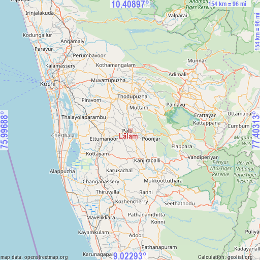
| Upper-left | 10.40897°, | 75.99688° |
| Center: | 9.71667°, | 76.7° |
| Lower-right: | 9.02293°, | 77.40313° |
| Map W x H: | 154.1×154.1 km | = 95.8×95.8mi |
| max Lat: | 34.9274° ⇑97.3% North |
| Lālam: | 9.71667° |
| min Lat: | ⇓2.7% South 8.09008° |
| min Long | Lālam | max Long |
| 68.82655° | 76.7° | 96.81° |
| W 33.7%⇐ | ⇒66.3% E |
Elevation
Elevation of Lālam is 55 m = 180 ft, and this is 240.6 m = 789 ft below average elevation for this country.
| Max E: |
3681 m = 12077 ft | 78% |
| Avg. | 295.6 m = 970 ft | |
| Lālam | 55 m = 180 ft | |
Min E: |
1 m = 3 ft | 22% |
See also: India elevation on elevation.city.
Geographical zone
Lālam is located in North Torrid zone (between Equator and Tropic of Cancer). Distance of Equator is 1080.4 km =671.3 mi to South.| Distance of | km | miles | from Lālam |
|---|---|---|---|
| North Pole | 8926.7 | 5546.8 | to North |
| Arctic Circle | 6320.8 | 3927.6 | to North |
| Tropic Cancer | 1525.5 | 947.9 | to North |
| Equator | 1080.4 | 671.3 | to South |


Nearby cities:
15 places around Lālam: (largest is in red/bold)
• Changanācheri
35.4 km =22 mi,  210°
210°
• Cherthala
40.1 km =24.9 mi,  264°
264°
• Erāttupetta
9.2 km =5.7 mi,  110°
110°
• Idukki
32.8 km =20.4 mi,  63°
63°
• Kotamangalam
39.4 km =24.5 mi,  348°
348°
• Kottayam
24.3 km =15.1 mi,  233°
233°
• Muvattupuzha
32.4 km =20.1 mi,  334°
334°
• Mūvattupula
32.7 km =20.3 mi,  335°
335°
• Palackattumala
8.3 km =5.2 mi,  291°
291°
• Piravam
27.5 km =17.1 mi,  307°
307°
• Rāmamangalam
32.6 km =20.3 mi,  317°
317°
• Shertallai
39.6 km =24.6 mi,  265°
265°
• Tiruvalla
39.7 km =24.7 mi,  200°
200°
• Vaikam
33.5 km =20.8 mi,  276°
276°
• Vayalār
39.6 km =24.6 mi, 269°
Sources, notices
• [Note1] Compared only with cities in India existing in our database
• [Src1] Map data: © OpenStreetMap contributors (CC-BY-SA)
• [Src2] Other city data from geonames.org with taken over terms of usage.
• [Src3] Geographical zone / Annual Mean Temperature by Robert A. Rohde @ Wikipedia
