Erāttupetta geodata
Erāttupetta (Kerala) is a populated place; located in India in Asia/Kolkata (GMT+5.5) time zone. With population of 33,408 people, there are 1301 cities with bigger population in this country. Compared to other cities in India, 97.4% of cities are located further ↑North; 65.3% of cities are located further →East and 85.5% of cities have higher elevation than Erāttupetta. Note1


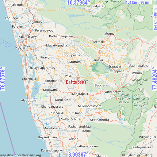
Erāttupetta GPS coordinates[2]
9° 41' 14.892" North, 76° 46' 44.076" East
| Map corner | latitude | longitude |
|---|---|---|
| Upper-left | 10.37984°, | 76.07579° |
| Center: | 9.68747°, | 76.77891° |
| Lower-right: | 8.99367°, | 77.48204° |
| Map W x H: | 154.1×154.1 km | = 95.8×95.8mi |
| max Lat: | 34.9274° ⇑97.4% North |
| Erāttupetta: | 9.68747° |
| min Lat: | ⇓2.6% South 8.09008° |
| min Long | Erāttupetta | max Long |
| 68.82655° | 76.77891° | 96.81° |
| W 34.7%⇐ | ⇒65.3% E |
Elevation
Elevation of Erāttupetta is 29 m = 95 ft, and this is 266.6 m = 875 ft below average elevation for this country.
| Max E: |
3681 m = 12077 ft | 85.5% |
| Avg. | 295.6 m = 970 ft | |
| Erāttupetta | 29 m = 95 ft | |
Min E: |
1 m = 3 ft | 14.5% |
See also: India elevation on elevation.city.
Geographical zone
Erāttupetta is located in North Torrid zone (between Equator and Tropic of Cancer). Distance of Equator is 1077.1 km =669.3 mi to South.| Distance of | km | miles | from Erāttupetta |
|---|---|---|---|
| North Pole | 8929.9 | 5548.8 | to North |
| Arctic Circle | 6324 | 3929.6 | to North |
| Tropic Cancer | 1528.8 | 950 | to North |
| Equator | 1077.1 | 669.3 | to South |


Nearby cities:
15 places around Erāttupetta: (largest is in red/bold)
• Changanācheri
38.1 km =23.7 mi,  224°
224°
• Chengannūr
45.1 km =28 mi,  203°
203°
• Idukki
27.4 km =17 mi,  48°
48°
• Kotamangalam
45 km =28 mi,  338°
338°
• Kottayam
30.4 km =18.9 mi,  248°
248°
• Lālam
9.2 km =5.7 mi,  290°
290°
• Muvattupuzha
39.5 km =24.5 mi,  325°
325°
• Mūvattupula
39.8 km =24.7 mi, 326°
• Palackattumala
17.5 km =10.9 mi, 290°
• Pathanāmthitta
46.8 km =29.1 mi,  179°
179°
• Piravam
36.5 km =22.7 mi,  303°
303°
• Rāmamangalam
41 km =25.5 mi,  311°
311°
• Shertallai
48.1 km =29.9 mi,  269°
269°
• Tiruvalla
40.7 km =25.3 mi,  213°
213°
• Vaikam
42.5 km =26.4 mi,  279°
279°
Sources, notices
• [Note1] Compared only with cities in India existing in our database
• [Src1] Map data: © OpenStreetMap contributors (CC-BY-SA)
• [Src2] Other city data from geonames.org with taken over terms of usage.
• [Src3] Geographical zone / Annual Mean Temperature by Robert A. Rohde @ Wikipedia
