Dīdwāna geodata
Dīdwāna (Rajasthan) is a populated place; located in India in Asia/Kolkata (GMT+5.5) time zone. With population of 49,852 people, there are 892 cities with bigger population in this country. Compared to other cities in India, 81.3% of cities are located further ↓South; 86.3% of cities are located further →East and 71.9% of cities have lower elevation than Dīdwāna. Note1


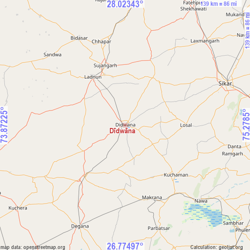
Dīdwāna GPS coordinates[2]
27° 24' 3.456" North, 74° 34' 31.332" East
| Map corner | latitude | longitude |
|---|---|---|
| Upper-left | 28.02343°, | 73.87225° |
| Center: | 27.40096°, | 74.57537° |
| Lower-right: | 26.77497°, | 75.2785° |
| Map W x H: | 138.8×138.8 km | = 86.2×86.2mi |
| max Lat: | 34.9274° ⇑18.7% North |
| Dīdwāna: | 27.40096° |
| min Lat: | ⇓81.3% South 8.09008° |
| min Long | Dīdwāna | max Long |
| 68.82655° | 74.57537° | 96.81° |
| W 13.7%⇐ | ⇒86.3% E |
Elevation
Elevation of Dīdwāna is 348 m = 1142 ft, and this is 52.4 m = 172 ft above average elevation for this country.
| Max E: |
3681 m = 12077 ft | 28.1% |
| Dīdwāna | 348 m 1142 ft | |
| Avg. | 295.6 m = 970 ft | |
Min E: |
1 m = 3 ft | 71.9% |
See also: Dīdwāna elevation on elevation.city.
Geographical zone
Dīdwāna is located in North temperate zone (between Tropic of Cancer and the Arctic Circle). Distance of this Northern Tropic circle is 440.8 km =273.9 mi to South.| Distance of | km | miles | from Dīdwāna |
|---|---|---|---|
| North Pole | 6960.4 | 4325 | to North |
| Arctic Circle | 4354.5 | 2705.8 | to North |
| Tropic Cancer | 440.8 | 273.9 | to South |
| Equator | 3046.7 | 1893.1 | to South |


Nearby cities:
15 places around Dīdwāna: (largest is in red/bold)
• Bhuma
55.2 km =34.3 mi,  39°
39°
• Chhāpar
48.4 km =30.1 mi,  343°
343°
• Kuchera
75.4 km =46.9 mi,  232°
232°
• Kuchāman
39.6 km =24.6 mi,  135°
135°
• Lachhmangarh Sīkar
64.7 km =40.2 mi, 43°
• Losal
33.7 km =20.9 mi,  90°
90°
• Lādnūn
32.9 km =20.4 mi,  328°
328°
• Makrāna
42.4 km =26.3 mi,  159°
159°
• Meethari Marwar
22.4 km =13.9 mi,  29°
29°
• Nāwa
59.8 km =37.2 mi, 135°
• Parvatsar
60.3 km =37.5 mi, 161°
• Rājaldesar
70.5 km =43.8 mi,  351°
351°
• Rāmgarh
61.9 km =38.5 mi,  105°
105°
• Sīkar
60.4 km =37.5 mi,  67°
67°
• Sūjāngarh
34.9 km =21.7 mi, 342°
Sources, notices
• [Note1] Compared only with cities in India existing in our database
• [Src1] Map data: © OpenStreetMap contributors (CC-BY-SA)
• [Src2] Other city data from geonames.org with taken over terms of usage.
• [Src3] Geographical zone / Annual Mean Temperature by Robert A. Rohde @ Wikipedia
