Jhunjhunūn geodata
Jhunjhunūn (Rajasthan) is a populated place; located in India in Asia/Kolkata (GMT+5.5) time zone. With population of 113,193 people, there are 389 cities with bigger population in this country. Compared to other cities in India, 85% of cities are located further ↓South; 79.2% of cities are located further →East and 71.5% of cities have lower elevation than Jhunjhunūn. Note1


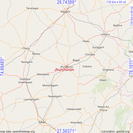
Jhunjhunūn GPS coordinates[2]
28° 7' 32.124" North, 75° 23' 52.692" East
| Map corner | latitude | longitude |
|---|---|---|
| Upper-left | 28.74389°, | 74.69485° |
| Center: | 28.12559°, | 75.39797° |
| Lower-right: | 27.50371°, | 76.1011° |
| Map W x H: | 137.9×137.9 km | = 85.7×85.7mi |
| max Lat: | 34.9274° ⇑15% North |
| Jhunjhunūn: | 28.12559° |
| min Lat: | ⇓85% South 8.09008° |
| min Long | Jhunjhunūn | max Long |
| 68.82655° | 75.39797° | 96.81° |
| W 20.8%⇐ | ⇒79.2% E |
Elevation
Elevation of Jhunjhunūn is 343 m = 1125 ft, and this is 47.4 m = 156 ft above average elevation for this country.
| Max E: |
3681 m = 12077 ft | 28.5% |
| Jhunjhunūn | 343 m 1125 ft | |
| Avg. | 295.6 m = 970 ft | |
Min E: |
1 m = 3 ft | 71.5% |
See also: Jhunjhunūn elevation on elevation.city.
Geographical zone
Jhunjhunūn is located in North temperate zone (between Tropic of Cancer and the Arctic Circle). Distance of this Northern Tropic circle is 521.4 km =324 mi to South.| Distance of | km | miles | from Jhunjhunūn |
|---|---|---|---|
| North Pole | 6879.8 | 4274.9 | to North |
| Arctic Circle | 4273.9 | 2655.7 | to North |
| Tropic Cancer | 521.4 | 324 | to South |
| Equator | 3127.3 | 1943.2 | to South |


Nearby cities:
15 places around Jhunjhunūn: (largest is in red/bold)
• Bagar
12.2 km =7.6 mi,  55°
55°
• Bissāu
34.3 km =21.3 mi,  293°
293°
• Chidawa
26.9 km =16.7 mi, 61°
• Chūru
46.6 km =29 mi,  295°
295°
• Fatehpur
45.7 km =28.4 mi,  251°
251°
• Khandela
58.8 km =36.5 mi,  169°
169°
• Khetri
40.6 km =25.2 mi,  110°
110°
• Lachhmangarh Sīkar
49.6 km =30.8 mi,  227°
227°
• Lohāru
52.5 km =32.6 mi,  49°
49°
• Nawalgarh
32.8 km =20.4 mi,  201°
201°
• Neem ka Thana
57.4 km =35.7 mi,  138°
138°
• Pilāni
33.6 km =20.9 mi,  36°
36°
• Rājgarh
57.4 km =35.7 mi,  358°
358°
• Sūrajgarh
38.7 km =24 mi, 57°
• Udaipur
45.4 km =28.2 mi, 170°
Sources, notices
• [Note1] Compared only with cities in India existing in our database
• [Src1] Map data: © OpenStreetMap contributors (CC-BY-SA)
• [Src2] Other city data from geonames.org with taken over terms of usage.
• [Src3] Geographical zone / Annual Mean Temperature by Robert A. Rohde @ Wikipedia
