Khandela geodata
Khandela (Rajasthan) is a populated place; located in India in Asia/Kolkata (GMT+5.5) time zone. With population of 23,164 people, there are 1824 cities with bigger population in this country. Compared to other cities in India, 82.6% of cities are located further ↓South; 78.5% of cities are located further →East and 81.9% of cities have lower elevation than Khandela. Note1


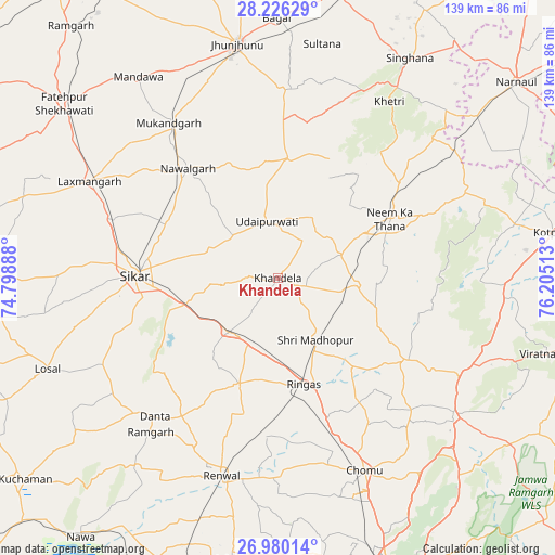
Khandela GPS coordinates[2]
27° 36' 17.964" North, 75° 30' 7.2" East
| Map corner | latitude | longitude |
|---|---|---|
| Upper-left | 28.22629°, | 74.79888° |
| Center: | 27.60499°, | 75.502° |
| Lower-right: | 26.98014°, | 76.20513° |
| Map W x H: | 138.6×138.6 km | = 86.1×86.1mi |
| max Lat: | 34.9274° ⇑17.4% North |
| Khandela: | 27.60499° |
| min Lat: | ⇓82.6% South 8.09008° |
| min Long | Khandela | max Long |
| 68.82655° | 75.502° | 96.81° |
| W 21.5%⇐ | ⇒78.5% E |
Elevation
Elevation of Khandela is 489 m = 1604 ft, and this is 193.4 m = 635 ft above average elevation for this country.
| Max E: |
3681 m = 12077 ft | 18.1% |
| Khandela | 489 m 1604 ft | |
| Avg. | 295.6 m = 970 ft | |
Min E: |
1 m = 3 ft | 81.9% |
See also: India elevation on elevation.city.
Geographical zone
Khandela is located in North temperate zone (between Tropic of Cancer and the Arctic Circle). Distance of this Northern Tropic circle is 463.5 km =288 mi to South.| Distance of | km | miles | from Khandela |
|---|---|---|---|
| North Pole | 6937.7 | 4310.9 | to North |
| Arctic Circle | 4331.8 | 2691.7 | to North |
| Tropic Cancer | 463.5 | 288 | to South |
| Equator | 3069.4 | 1907.2 | to South |


Nearby cities:
15 places around Khandela: (largest is in red/bold)
• Bagar
64.8 km =40.3 mi,  359°
359°
• Bhuma
59.4 km =36.9 mi,  289°
289°
• Jhunjhunūn
58.8 km =36.5 mi,  349°
349°
• Khetri
52.1 km =32.4 mi,  32°
32°
• Lachhmangarh Sīkar
52.6 km =32.7 mi,  297°
297°
• Losal
62.1 km =38.6 mi,  248°
248°
• Manoharpur
55.8 km =34.7 mi,  127°
127°
• Nawalgarh
35.4 km =22 mi,  320°
320°
• Neem ka Thana
31.8 km =19.8 mi,  61°
61°
• Rāmgarh
50.7 km =31.5 mi,  219°
219°
• Rīngas
27.6 km =17.1 mi,  166°
166°
• Shāhpura
51 km =31.7 mi,  117°
117°
• Sri Mādhopur
18.1 km =11.2 mi,  148°
148°
• Sīkar
35.7 km =22.2 mi,  271°
271°
• Udaipur
13.5 km =8.4 mi, 347°
Sources, notices
• [Note1] Compared only with cities in India existing in our database
• [Src1] Map data: © OpenStreetMap contributors (CC-BY-SA)
• [Src2] Other city data from geonames.org with taken over terms of usage.
• [Src3] Geographical zone / Annual Mean Temperature by Robert A. Rohde @ Wikipedia
