Jamkhandi geodata
Jamkhandi (Karnataka) is a populated place; located in India in Asia/Kolkata (GMT+5.5) time zone. With population of 61,690 people, there are 712 cities with bigger population in this country. Compared to other cities in India, 76.4% of cities are located further ↑North; 80.3% of cities are located further →East and 86.1% of cities have lower elevation than Jamkhandi. Note1


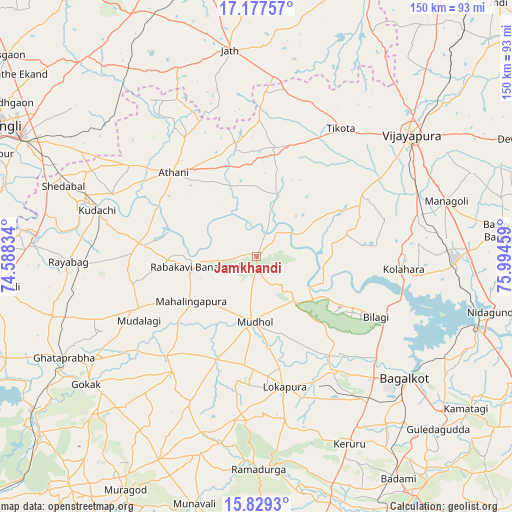
Jamkhandi GPS coordinates[2]
16° 30' 16.596" North, 75° 17' 29.256" East
| Map corner | latitude | longitude |
|---|---|---|
| Upper-left | 17.17757°, | 74.58834° |
| Center: | 16.50461°, | 75.29146° |
| Lower-right: | 15.8293°, | 75.99459° |
| Map W x H: | 149.9×149.9 km | = 93.1×93.1mi |
| max Lat: | 34.9274° ⇑76.4% North |
| Jamkhandi: | 16.50461° |
| min Lat: | ⇓23.6% South 8.09008° |
| min Long | Jamkhandi | max Long |
| 68.82655° | 75.29146° | 96.81° |
| W 19.7%⇐ | ⇒80.3% E |
Elevation
Elevation of Jamkhandi is 563 m = 1847 ft, and this is 267.4 m = 877 ft above average elevation for this country.
| Max E: |
3681 m = 12077 ft | 13.9% |
| Jamkhandi | 563 m 1847 ft | |
| Avg. | 295.6 m = 970 ft | |
Min E: |
1 m = 3 ft | 86.1% |
See also: Jamkhandi elevation on elevation.city.
Geographical zone
Jamkhandi is located in North Torrid zone (between Equator and Tropic of Cancer). Distance of this Northern Tropic circle is 770.8 km =479 mi to North.| Distance of | km | miles | from Jamkhandi |
|---|---|---|---|
| North Pole | 8171.9 | 5077.8 | to North |
| Arctic Circle | 5566 | 3458.6 | to North |
| Tropic Cancer | 770.8 | 479 | to North |
| Equator | 1835.1 | 1140.3 | to South |


Nearby cities:
15 places around Jamkhandi: (largest is in red/bold)
• Athni
34.5 km =21.4 mi,  315°
315°
• Bagalkot
55.8 km =34.7 mi,  129°
129°
• Basavana Bāgevādi
73 km =45.4 mi,  84°
84°
• Bijapur
57.5 km =35.7 mi,  51°
51°
• Bilgi
39 km =24.2 mi,  116°
116°
• Gokak
62.3 km =38.7 mi,  233°
233°
• Kerūr
61 km =37.9 mi,  153°
153°
• Konnūr
67 km =41.6 mi,  239°
239°
• Kudachi
48.6 km =30.2 mi,  286°
286°
• Mahālingpur
23.4 km =14.5 mi, 236°
• Mudhol
19 km =11.8 mi,  182°
182°
• Rabkavi
19.5 km =12.1 mi,  260°
260°
• Rāybāg
55.2 km =34.3 mi,  268°
268°
• Shiraguppi
63.4 km =39.4 mi,  281°
281°
• Terdāl
26.1 km =16.2 mi, 267°
Sources, notices
• [Note1] Compared only with cities in India existing in our database
• [Src1] Map data: © OpenStreetMap contributors (CC-BY-SA)
• [Src2] Other city data from geonames.org with taken over terms of usage.
• [Src3] Geographical zone / Annual Mean Temperature by Robert A. Rohde @ Wikipedia
