Medinīpur geodata
Medinīpur (West Bengal) is a populated place; located in India in Asia/Kolkata (GMT+5.5) time zone. With population of 153,349 people, there are 285 cities with bigger population in this country. Compared to other cities in India, 53.7% of cities are located further ↑North; 89.9% of cities are located further ←West and 80.2% of cities have higher elevation than Medinīpur. Note1


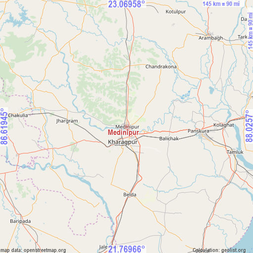
Medinīpur GPS coordinates[2]
22° 25' 16.104" North, 87° 19' 21.252" East
| Map corner | latitude | longitude |
|---|---|---|
| Upper-left | 23.06958°, | 86.61945° |
| Center: | 22.42114°, | 87.32257° |
| Lower-right: | 21.76966°, | 88.0257° |
| Map W x H: | 144.5×144.5 km | = 89.8×89.8mi |
| max Lat: | 34.9274° ⇑53.7% North |
| Medinīpur: | 22.42114° |
| min Lat: | ⇓46.3% South 8.09008° |
| min Long | Medinīpur | max Long |
| 68.82655° | 87.32257° | 96.81° |
| W 89.9%⇐ | ⇒10.1% E |
Elevation
Elevation of Medinīpur is 47 m = 154 ft, and this is 248.6 m = 816 ft below average elevation for this country.
| Max E: |
3681 m = 12077 ft | 80.2% |
| Avg. | 295.6 m = 970 ft | |
| Medinīpur | 47 m = 154 ft | |
Min E: |
1 m = 3 ft | 19.8% |
See also: Medinīpur elevation on elevation.city.
Geographical zone
Medinīpur is located in North Torrid zone (between Equator and Tropic of Cancer). Distance of this Northern Tropic circle is 112.9 km =70.2 mi to North.| Distance of | km | miles | from Medinīpur |
|---|---|---|---|
| North Pole | 7514.1 | 4669 | to North |
| Arctic Circle | 4908.2 | 3049.8 | to North |
| Tropic Cancer | 112.9 | 70.2 | to North |
| Equator | 2493 | 1549.1 | to South |


Nearby cities:
15 places around Medinīpur: (largest is in red/bold)
• Arāmbāgh
69.8 km =43.4 mi,  42°
42°
• Bāli Chak
24.5 km =15.2 mi,  104°
104°
• Chandrakona
40 km =24.9 mi,  29°
29°
• Chākuliā
62.5 km =38.8 mi,  276°
276°
• Egra
62.1 km =38.6 mi,  159°
159°
• Ghātāl
50 km =31.1 mi,  57°
57°
• Jaleshwar
69.6 km =43.2 mi,  188°
188°
• Jhārgrām
33.9 km =21.1 mi, 276°
• Kalaīkunda
13.4 km =8.3 mi,  227°
227°
• Kharagpur
9.1 km =5.7 mi,  178°
178°
• Kharar
49.5 km =30.8 mi,  47°
47°
• Mahīshādal
72.6 km =45.1 mi,  111°
111°
• Rāmjībanpur
54 km =33.6 mi, 32°
• Tamlūk
63.5 km =39.5 mi, 102°
• Āmlāgora
47.3 km =29.4 mi,  1°
1°
Sources, notices
• [Note1] Compared only with cities in India existing in our database
• [Src1] Map data: © OpenStreetMap contributors (CC-BY-SA)
• [Src2] Other city data from geonames.org with taken over terms of usage.
• [Src3] Geographical zone / Annual Mean Temperature by Robert A. Rohde @ Wikipedia
