Khanna geodata
Khanna (Punjab) is a populated place; located in India in Asia/Kolkata (GMT+5.5) time zone. With population of 117,137 people, there are 377 cities with bigger population in this country. Compared to other cities in India, 94.9% of cities are located further ↓South; 71.4% of cities are located further →East and 62.7% of cities have lower elevation than Khanna. Note1


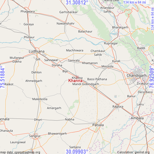
Khanna GPS coordinates[2]
30° 42' 19.692" North, 76° 13' 19.056" East
| Map corner | latitude | longitude |
|---|---|---|
| Upper-left | 31.30812°, | 75.51884° |
| Center: | 30.70547°, | 76.22196° |
| Lower-right: | 30.09903°, | 76.92509° |
| Map W x H: | 134.4×134.4 km | = 83.5×83.5mi |
| max Lat: | 34.9274° ⇑5.1% North |
| Khanna: | 30.70547° |
| min Lat: | ⇓94.9% South 8.09008° |
| min Long | Khanna | max Long |
| 68.82655° | 76.22196° | 96.81° |
| W 28.6%⇐ | ⇒71.4% E |
Elevation
Elevation of Khanna is 269 m = 883 ft, and this is 26.6 m = 87 ft below average elevation for this country.
| Max E: |
3681 m = 12077 ft | 37.3% |
| Avg. | 295.6 m = 970 ft | |
| Khanna | 269 m = 883 ft | |
Min E: |
1 m = 3 ft | 62.7% |
See also: Khanna elevation on elevation.city.
Geographical zone
Khanna is located in North temperate zone (between Tropic of Cancer and the Arctic Circle). Distance of this Northern Tropic circle is 808.2 km =502.2 mi to South.| Distance of | km | miles | from Khanna |
|---|---|---|---|
| North Pole | 6592.9 | 4096.6 | to North |
| Arctic Circle | 3987 | 2477.4 | to North |
| Tropic Cancer | 808.2 | 502.2 | to South |
| Equator | 3414.1 | 2121.4 | to South |


Nearby cities:
15 places around Khanna: (largest is in red/bold)
• Amloh
10.8 km =6.7 mi,  174°
174°
• Basi
17.2 km =10.7 mi,  96°
96°
• Bālāchor
40.2 km =25 mi,  10°
10°
• Chīma
13.1 km =8.1 mi,  260°
260°
• Dorāha
21.7 km =13.5 mi,  298°
298°
• Khamānon Kalān
17.8 km =11.1 mi,  45°
45°
• Kharar
40.9 km =25.4 mi,  83°
83°
• Morinda
28.1 km =17.5 mi,  70°
70°
• Māchhīwāra
23.5 km =14.6 mi,  354°
354°
• Māler Kotla
38.1 km =23.7 mi,  239°
239°
• Nābha
37.3 km =23.2 mi,  190°
190°
• Ropar
41.3 km =25.7 mi,  44°
44°
• Rāhon
39.8 km =24.7 mi, 345°
• Samrāla
14.8 km =9.2 mi, 349°
• Sirhind
17 km =10.6 mi,  114°
114°
Sources, notices
• [Note1] Compared only with cities in India existing in our database
• [Src1] Map data: © OpenStreetMap contributors (CC-BY-SA)
• [Src2] Other city data from geonames.org with taken over terms of usage.
• [Src3] Geographical zone / Annual Mean Temperature by Robert A. Rohde @ Wikipedia
