Dorāha geodata
Dorāha (Punjab) is a populated place; located in India in Asia/Kolkata (GMT+5.5) time zone. With population of 23,545 people, there are 1795 cities with bigger population in this country. Compared to other cities in India, 95.2% of cities are located further ↓South; 73.4% of cities are located further →East and 61.5% of cities have lower elevation than Dorāha. Note1


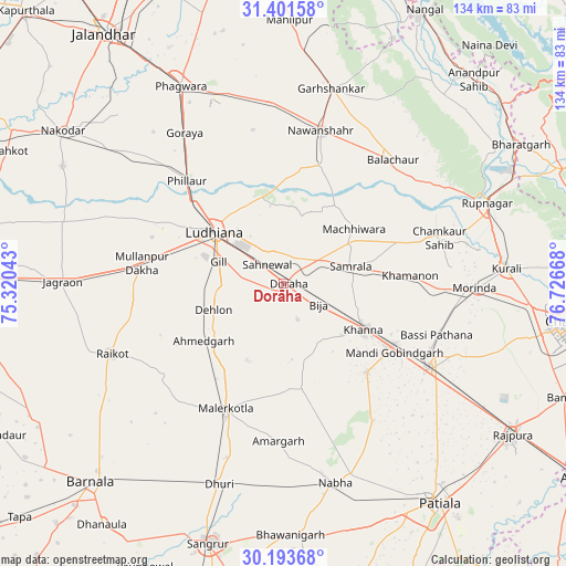
Dorāha GPS coordinates[2]
30° 47' 58.308" North, 76° 1' 24.78" East
| Map corner | latitude | longitude |
|---|---|---|
| Upper-left | 31.40158°, | 75.32043° |
| Center: | 30.79953°, | 76.02355° |
| Lower-right: | 30.19368°, | 76.72668° |
| Map W x H: | 134.3×134.3 km | = 83.5×83.5mi |
| max Lat: | 34.9274° ⇑4.8% North |
| Dorāha: | 30.79953° |
| min Lat: | ⇓95.2% South 8.09008° |
| min Long | Dorāha | max Long |
| 68.82655° | 76.02355° | 96.81° |
| W 26.6%⇐ | ⇒73.4% E |
Elevation
Elevation of Dorāha is 262 m = 860 ft, and this is 33.6 m = 110 ft below average elevation for this country.
| Max E: |
3681 m = 12077 ft | 38.5% |
| Avg. | 295.6 m = 970 ft | |
| Dorāha | 262 m = 860 ft | |
Min E: |
1 m = 3 ft | 61.5% |
See also: India elevation on elevation.city.
Geographical zone
Dorāha is located in North temperate zone (between Tropic of Cancer and the Arctic Circle). Distance of this Northern Tropic circle is 818.7 km =508.7 mi to South.| Distance of | km | miles | from Dorāha |
|---|---|---|---|
| North Pole | 6582.5 | 4090.2 | to North |
| Arctic Circle | 3976.6 | 2470.9 | to North |
| Tropic Cancer | 818.7 | 508.7 | to South |
| Equator | 3424.6 | 2127.9 | to South |


Nearby cities:
15 places around Dorāha: (largest is in red/bold)
• Amloh
29.1 km =18.1 mi,  136°
136°
• Banga
43.4 km =27 mi,  356°
356°
• Basi
38.1 km =23.7 mi,  108°
108°
• Bālāchor
39.3 km =24.4 mi,  42°
42°
• Chīma
14 km =8.7 mi,  154°
154°
• Khamānon Kalān
31.7 km =19.7 mi,  86°
86°
• Khanna
21.7 km =13.5 mi,  118°
118°
• Ludhiāna
20.5 km =12.7 mi,  307°
307°
• Māchhīwāra
21.2 km =13.2 mi,  52°
52°
• Māler Kotla
32.9 km =20.4 mi,  204°
204°
• Nawanshahr
37.2 km =23.1 mi,  13°
13°
• Phillaur
33 km =20.5 mi,  317°
317°
• Rāhon
29.6 km =18.4 mi,  17°
17°
• Samrāla
16.7 km =10.4 mi,  75°
75°
• Sirhind
38.6 km =24 mi, 116°
Sources, notices
• [Note1] Compared only with cities in India existing in our database
• [Src1] Map data: © OpenStreetMap contributors (CC-BY-SA)
• [Src2] Other city data from geonames.org with taken over terms of usage.
• [Src3] Geographical zone / Annual Mean Temperature by Robert A. Rohde @ Wikipedia
