Māler Kotla geodata
Māler Kotla (Punjab) is a populated place; located in India in Asia/Kolkata (GMT+5.5) time zone. With population of 113,840 people, there are 387 cities with bigger population in this country. Compared to other cities in India, 94.4% of cities are located further ↓South; 74.9% of cities are located further →East and 60.1% of cities have lower elevation than Māler Kotla. Note1


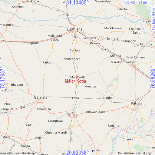
Māler Kotla GPS coordinates[2]
30° 31' 51.24" North, 75° 52' 46.164" East
| Map corner | latitude | longitude |
|---|---|---|
| Upper-left | 31.13465°, | 75.17637° |
| Center: | 30.5309°, | 75.87949° |
| Lower-right: | 29.92338°, | 76.58262° |
| Map W x H: | 134.7×134.7 km | = 83.7×83.7mi |
| max Lat: | 34.9274° ⇑5.6% North |
| Māler Kotla: | 30.5309° |
| min Lat: | ⇓94.4% South 8.09008° |
| min Long | Māler Kotla | max Long |
| 68.82655° | 75.87949° | 96.81° |
| W 25.1%⇐ | ⇒74.9% E |
Elevation
Elevation of Māler Kotla is 251 m = 823 ft, and this is 44.6 m = 146 ft below average elevation for this country.
| Max E: |
3681 m = 12077 ft | 39.9% |
| Avg. | 295.6 m = 970 ft | |
| Māler Kotla | 251 m = 823 ft | |
Min E: |
1 m = 3 ft | 60.1% |
See also: Māler Kotla elevation on elevation.city.
Geographical zone
Māler Kotla is located in North temperate zone (between Tropic of Cancer and the Arctic Circle). Distance of this Northern Tropic circle is 788.8 km =490.1 mi to South.| Distance of | km | miles | from Māler Kotla |
|---|---|---|---|
| North Pole | 6612.3 | 4108.7 | to North |
| Arctic Circle | 4006.5 | 2489.5 | to North |
| Tropic Cancer | 788.8 | 490.1 | to South |
| Equator | 3394.7 | 2109.4 | to South |


Nearby cities:
15 places around Māler Kotla: (largest is in red/bold)
• Amloh
34.8 km =21.6 mi,  75°
75°
• Barnāla
36.2 km =22.5 mi,  241°
241°
• Bhawānīgarh
33.1 km =20.6 mi,  152°
152°
• Chīma
26.2 km =16.3 mi,  49°
49°
• Dhanaula
40.3 km =25 mi,  226°
226°
• Dhūri
18.1 km =11.2 mi,  183°
183°
• Dorāha
32.9 km =20.4 mi,  24°
24°
• Khanna
38.1 km =23.7 mi,  59°
59°
• Laungowāl
42 km =26.1 mi,  206°
206°
• Ludhiāna
42.4 km =26.3 mi,  356°
356°
• Nābha
31.4 km =19.5 mi,  123°
123°
• Rāikot
29.8 km =18.5 mi,  296°
296°
• Samrāla
45.3 km =28.1 mi,  41°
41°
• Sangrūr
32 km =19.9 mi,  185°
185°
• Sunām
45.4 km =28.2 mi, 189°
Sources, notices
• [Note1] Compared only with cities in India existing in our database
• [Src1] Map data: © OpenStreetMap contributors (CC-BY-SA)
• [Src2] Other city data from geonames.org with taken over terms of usage.
• [Src3] Geographical zone / Annual Mean Temperature by Robert A. Rohde @ Wikipedia
