Kharar geodata
Kharar (Punjab) is a populated place; located in India in Asia/Kolkata (GMT+5.5) time zone. With population of 45,691 people, there are 968 cities with bigger population in this country. Compared to other cities in India, 95% of cities are located further ↓South; 66.8% of cities are located further →East and 68.7% of cities have lower elevation than Kharar. Note1


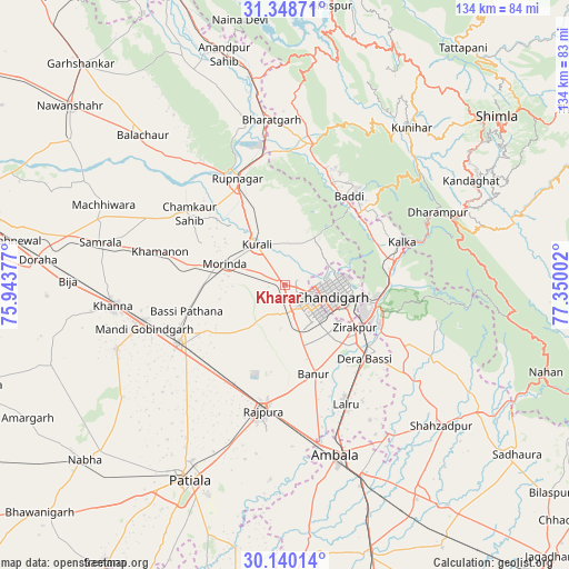
Kharar GPS coordinates[2]
30° 44' 46.752" North, 76° 38' 48.804" East
| Map corner | latitude | longitude |
|---|---|---|
| Upper-left | 31.34871°, | 75.94377° |
| Center: | 30.74632°, | 76.64689° |
| Lower-right: | 30.14014°, | 77.35002° |
| Map W x H: | 134.4×134.4 km | = 83.5×83.5mi |
| max Lat: | 34.9274° ⇑5% North |
| Kharar: | 30.74632° |
| min Lat: | ⇓95% South 8.09008° |
| min Long | Kharar | max Long |
| 68.82655° | 76.64689° | 96.81° |
| W 33.2%⇐ | ⇒66.8% E |
Elevation
Elevation of Kharar is 313 m = 1027 ft, and this is 17.4 m = 57 ft above average elevation for this country.
| Max E: |
3681 m = 12077 ft | 31.3% |
| Kharar | 313 m 1027 ft | |
| Avg. | 295.6 m = 970 ft | |
Min E: |
1 m = 3 ft | 68.7% |
See also: Kharar elevation on elevation.city.
Geographical zone
Kharar is located in North temperate zone (between Tropic of Cancer and the Arctic Circle). Distance of this Northern Tropic circle is 812.8 km =505.1 mi to South.| Distance of | km | miles | from Kharar |
|---|---|---|---|
| North Pole | 6588.4 | 4093.8 | to North |
| Arctic Circle | 3982.5 | 2474.6 | to North |
| Tropic Cancer | 812.8 | 505.1 | to South |
| Equator | 3418.7 | 2124.3 | to South |


Nearby cities:
15 places around Kharar: (largest is in red/bold)
• Baddi
27.3 km =17 mi,  30°
30°
• Banūr
22.5 km =14 mi,  162°
162°
• Basi
24.4 km =15.2 mi,  254°
254°
• Basi
25.9 km =16.1 mi,  132°
132°
• Chandigarh
13.6 km =8.5 mi,  94°
94°
• Khamānon Kalān
29 km =18 mi,  285°
285°
• Kālka
29.9 km =18.6 mi,  69°
69°
• Mohali
10.3 km =6.4 mi,  135°
135°
• Morinda
15 km =9.3 mi, 289°
• Panchkula
20.3 km =12.6 mi,  106°
106°
• Parwanoo
31.7 km =19.7 mi, 71°
• Pinjaur
26.6 km =16.5 mi,  77°
77°
• Ropar
27.3 km =17 mi,  335°
335°
• Rājpura
30.2 km =18.8 mi,  189°
189°
• Sirhind
27.6 km =17.1 mi, 245°
Sources, notices
• [Note1] Compared only with cities in India existing in our database
• [Src1] Map data: © OpenStreetMap contributors (CC-BY-SA)
• [Src2] Other city data from geonames.org with taken over terms of usage.
• [Src3] Geographical zone / Annual Mean Temperature by Robert A. Rohde @ Wikipedia
