Rāhon geodata
Rāhon (Punjab) is a populated place; located in India in Asia/Kolkata (GMT+5.5) time zone. With population of 12,485 people, there are 2702 cities with bigger population in this country. Compared to other cities in India, 95.8% of cities are located further ↓South; 72.5% of cities are located further →East and 61.8% of cities have lower elevation than Rāhon. Note1


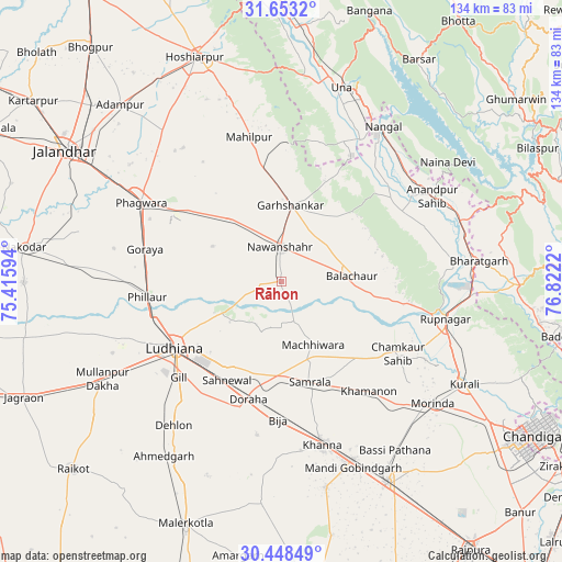
Rāhon GPS coordinates[2]
31° 3' 9.9" North, 76° 7' 8.652" East
| Map corner | latitude | longitude |
|---|---|---|
| Upper-left | 31.6532°, | 75.41594° |
| Center: | 31.05275°, | 76.11907° |
| Lower-right: | 30.44849°, | 76.8222° |
| Map W x H: | 134×134 km | = 83.3×83.3mi |
| max Lat: | 34.9274° ⇑4.2% North |
| Rāhon: | 31.05275° |
| min Lat: | ⇓95.8% South 8.09008° |
| min Long | Rāhon | max Long |
| 68.82655° | 76.11907° | 96.81° |
| W 27.5%⇐ | ⇒72.5% E |
Elevation
Elevation of Rāhon is 263 m = 863 ft, and this is 32.6 m = 107 ft below average elevation for this country.
| Max E: |
3681 m = 12077 ft | 38.2% |
| Avg. | 295.6 m = 970 ft | |
| Rāhon | 263 m = 863 ft | |
Min E: |
1 m = 3 ft | 61.8% |
See also: India elevation on elevation.city.
Geographical zone
Rāhon is located in North temperate zone (between Tropic of Cancer and the Arctic Circle). Distance of this Northern Tropic circle is 846.8 km =526.2 mi to South.| Distance of | km | miles | from Rāhon |
|---|---|---|---|
| North Pole | 6554.3 | 4072.7 | to North |
| Arctic Circle | 3948.4 | 2453.4 | to North |
| Tropic Cancer | 846.8 | 526.2 | to South |
| Equator | 3452.7 | 2145.4 | to South |


Nearby cities:
15 places around Rāhon: (largest is in red/bold)
• Banga
19.2 km =11.9 mi,  321°
321°
• Bālāchor
17.4 km =10.8 mi,  87°
87°
• Dorāha
29.6 km =18.4 mi,  197°
197°
• Garhshankar
18.2 km =11.3 mi,  6°
6°
• Khamānon Kalān
34.5 km =21.4 mi,  139°
139°
• Khanna
39.8 km =24.7 mi,  165°
165°
• Ludhiāna
29.7 km =18.5 mi,  238°
238°
• Māchhīwāra
17.1 km =10.6 mi,  153°
153°
• Nawanshahr
8 km =5 mi,  357°
357°
• Nūrpur Kalān
36.9 km =22.9 mi,  69°
69°
• Phagwāra
38 km =23.6 mi,  300°
300°
• Phillaur
31.5 km =19.6 mi,  263°
263°
• Ropar
40 km =24.9 mi,  103°
103°
• Samrāla
25.1 km =15.6 mi,  163°
163°
• Santokhgarh
38.3 km =23.8 mi,  29°
29°
Sources, notices
• [Note1] Compared only with cities in India existing in our database
• [Src1] Map data: © OpenStreetMap contributors (CC-BY-SA)
• [Src2] Other city data from geonames.org with taken over terms of usage.
• [Src3] Geographical zone / Annual Mean Temperature by Robert A. Rohde @ Wikipedia
