Sirhind geodata
Sirhind (Punjab) is a populated place; located in India in Asia/Kolkata (GMT+5.5) time zone. With population of 60,847 people, there are 719 cities with bigger population in this country. Compared to other cities in India, 94.6% of cities are located further ↓South; 69.5% of cities are located further →East and 62.8% of cities have lower elevation than Sirhind. Note1


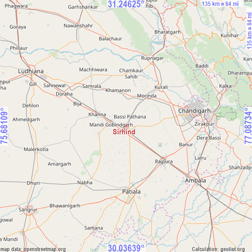
Sirhind GPS coordinates[2]
30° 38' 35.556" North, 76° 23' 3.156" East
| Map corner | latitude | longitude |
|---|---|---|
| Upper-left | 31.24625°, | 75.68109° |
| Center: | 30.64321°, | 76.38421° |
| Lower-right: | 30.03639°, | 77.08734° |
| Map W x H: | 134.5×134.5 km | = 83.6×83.6mi |
| max Lat: | 34.9274° ⇑5.4% North |
| Sirhind: | 30.64321° |
| min Lat: | ⇓94.6% South 8.09008° |
| min Long | Sirhind | max Long |
| 68.82655° | 76.38421° | 96.81° |
| W 30.5%⇐ | ⇒69.5% E |
Elevation
Elevation of Sirhind is 270 m = 886 ft, and this is 25.6 m = 84 ft below average elevation for this country.
| Max E: |
3681 m = 12077 ft | 37.2% |
| Avg. | 295.6 m = 970 ft | |
| Sirhind | 270 m = 886 ft | |
Min E: |
1 m = 3 ft | 62.8% |
See also: Sirhind elevation on elevation.city.
Geographical zone
Sirhind is located in North temperate zone (between Tropic of Cancer and the Arctic Circle). Distance of this Northern Tropic circle is 801.3 km =497.9 mi to South.| Distance of | km | miles | from Sirhind |
|---|---|---|---|
| North Pole | 6599.9 | 4101 | to North |
| Arctic Circle | 3994 | 2481.8 | to North |
| Tropic Cancer | 801.3 | 497.9 | to South |
| Equator | 3407.2 | 2117.1 | to South |


Nearby cities:
15 places around Sirhind: (largest is in red/bold)
• Amloh
15.1 km =9.4 mi,  255°
255°
• Banūr
33.6 km =20.9 mi,  107°
107°
• Basi
5.3 km =3.3 mi,  17°
17°
• Chīma
28.9 km =18 mi,  279°
279°
• Khamānon Kalān
19.6 km =12.2 mi,  351°
351°
• Khanna
17 km =10.6 mi,  294°
294°
• Kharar
27.6 km =17.1 mi,  65°
65°
• Mohali
32.6 km =20.3 mi,  82°
82°
• Morinda
19.7 km =12.2 mi,  33°
33°
• Māchhīwāra
35 km =21.7 mi,  329°
329°
• Nābha
37.1 km =23.1 mi,  216°
216°
• Patiāla
34.1 km =21.2 mi,  178°
178°
• Rājpura
27.1 km =16.8 mi,  132°
132°
• Samrāla
28.2 km =17.5 mi,  319°
319°
• Sanaur
38.6 km =24 mi,  169°
169°
Sources, notices
• [Note1] Compared only with cities in India existing in our database
• [Src1] Map data: © OpenStreetMap contributors (CC-BY-SA)
• [Src2] Other city data from geonames.org with taken over terms of usage.
• [Src3] Geographical zone / Annual Mean Temperature by Robert A. Rohde @ Wikipedia
