Kendrāparha geodata
Kendrāparha (Odisha) is a populated place; located in India in Asia/Kolkata (GMT+5.5) time zone. With population of 43,843 people, there are 1007 cities with bigger population in this country. Compared to other cities in India, 63.7% of cities are located further ↑North; 88% of cities are located further ←West and 98.3% of cities have higher elevation than Kendrāparha. Note1


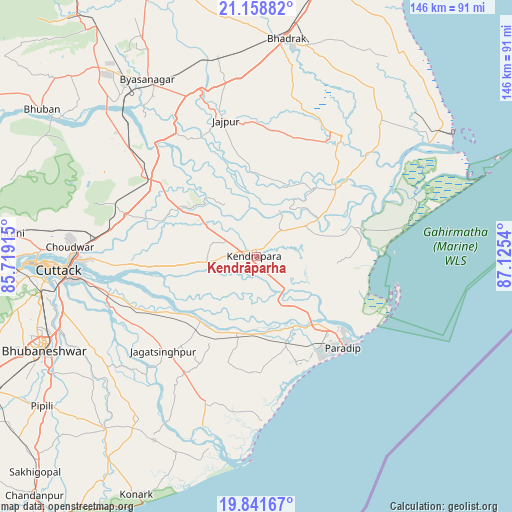
Kendrāparha GPS coordinates[2]
20° 30' 5.976" North, 86° 25' 20.172" East
| Map corner | latitude | longitude |
|---|---|---|
| Upper-left | 21.15882°, | 85.71915° |
| Center: | 20.50166°, | 86.42227° |
| Lower-right: | 19.84167°, | 87.1254° |
| Map W x H: | 146.5×146.5 km | = 91×91mi |
| max Lat: | 34.9274° ⇑63.7% North |
| Kendrāparha: | 20.50166° |
| min Lat: | ⇓36.3% South 8.09008° |
| min Long | Kendrāparha | max Long |
| 68.82655° | 86.42227° | 96.81° |
| W 88%⇐ | ⇒12% E |
Elevation
Elevation of Kendrāparha is 8 m = 26 ft, and this is 287.6 m = 944 ft below average elevation for this country.
| Max E: |
3681 m = 12077 ft | 98.3% |
| Avg. | 295.6 m = 970 ft | |
| Kendrāparha | 8 m = 26 ft | |
Min E: |
1 m = 3 ft | 1.7% |
See also: Kendrāparha elevation on elevation.city.
Geographical zone
Kendrāparha is located in North Torrid zone (between Equator and Tropic of Cancer). Distance of this Northern Tropic circle is 326.3 km =202.8 mi to North.| Distance of | km | miles | from Kendrāparha |
|---|---|---|---|
| North Pole | 7727.5 | 4801.6 | to North |
| Arctic Circle | 5121.6 | 3182.4 | to North |
| Tropic Cancer | 326.3 | 202.8 | to North |
| Equator | 2279.6 | 1416.5 | to South |


Nearby cities:
15 places around Kendrāparha: (largest is in red/bold)
• Bhadrakh
62.2 km =38.6 mi,  8°
8°
• Bhuban
74.4 km =46.2 mi,  304°
304°
• Bhubaneshwar
66.4 km =41.3 mi,  247°
247°
• Bāsudebpur
75.8 km =47.1 mi,  24°
24°
• Chāndbāli
45 km =28 mi,  47°
47°
• Cuttack
56.7 km =35.2 mi,  265°
265°
• Jagatsinghapur
37.9 km =23.5 mi,  223°
223°
• Jatani
83.7 km =52 mi,  242°
242°
• Jājpur
39.6 km =24.6 mi,  347°
347°
• Konārka
74.5 km =46.3 mi,  205°
205°
• Nimāparha
65.9 km =40.9 mi, 221°
• Parādīp Garh
28.3 km =17.6 mi,  136°
136°
• Patāmundai
16.7 km =10.4 mi,  59°
59°
• Pipili
75.2 km =46.7 mi,  234°
234°
• Āthagarh
82.6 km =51.3 mi, 271°
Sources, notices
• [Note1] Compared only with cities in India existing in our database
• [Src1] Map data: © OpenStreetMap contributors (CC-BY-SA)
• [Src2] Other city data from geonames.org with taken over terms of usage.
• [Src3] Geographical zone / Annual Mean Temperature by Robert A. Rohde @ Wikipedia
