Bhubaneshwar geodata
Bhubaneshwar (Odisha) is a seat of a first-order administrative division; located in India in Asia/Kolkata (GMT+5.5) time zone. With population of 762,243 people, there are 61 cities with bigger population in this country. Compared to other cities in India, 64.4% of cities are located further ↑North; 86.5% of cities are located further ←West and 76.3% of cities have higher elevation than Bhubaneshwar. Note1


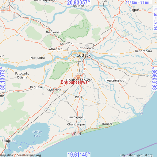
Bhubaneshwar GPS coordinates[2]
20° 16' 20.676" North, 85° 50' 1.86" East
| Map corner | latitude | longitude |
|---|---|---|
| Upper-left | 20.93057°, | 85.13073° |
| Center: | 20.27241°, | 85.83385° |
| Lower-right: | 19.61145°, | 86.53698° |
| Map W x H: | 146.7×146.7 km | = 91.2×91.2mi |
| max Lat: | 34.9274° ⇑64.4% North |
| Bhubaneshwar: | 20.27241° |
| min Lat: | ⇓35.6% South 8.09008° |
| min Long | Bhubaneshwar | max Long |
| 68.82655° | 85.83385° | 96.81° |
| W 86.5%⇐ | ⇒13.5% E |
Elevation
Elevation of Bhubaneshwar is 62 m = 203 ft, and this is 233.6 m = 766 ft below average elevation for this country.
| Max E: |
3681 m = 12077 ft | 76.3% |
| Avg. | 295.6 m = 970 ft | |
| Bhubaneshwar | 62 m = 203 ft | |
Min E: |
1 m = 3 ft | 23.7% |
See also: Bhubaneshwar elevation on elevation.city.
Geographical zone
Bhubaneshwar is located in North Torrid zone (between Equator and Tropic of Cancer). Distance of this Northern Tropic circle is 351.8 km =218.6 mi to North.| Distance of | km | miles | from Bhubaneshwar |
|---|---|---|---|
| North Pole | 7753 | 4817.5 | to North |
| Arctic Circle | 5147.1 | 3198.3 | to North |
| Tropic Cancer | 351.8 | 218.6 | to North |
| Equator | 2254.1 | 1400.6 | to South |


Nearby cities:
15 places around Bhubaneshwar: (largest is in red/bold)
• Bhuban
67.8 km =42.1 mi,  359°
359°
• Bālugaon
75.9 km =47.2 mi,  262°
262°
• Bānki
33.9 km =21.1 mi,  290°
290°
• Cuttack
21.9 km =13.6 mi,  12°
12°
• Dhenkānāl
49.4 km =30.7 mi,  330°
330°
• Jagatsinghapur
35.2 km =21.9 mi,  93°
93°
• Jatani
18.2 km =11.3 mi,  226°
226°
• Kantilo
67.6 km =42 mi,  278°
278°
• Kendrāparha
66.4 km =41.3 mi,  67°
67°
• Khurda
24.8 km =15.4 mi,  246°
246°
• Konārka
50.9 km =31.6 mi,  144°
144°
• Nimāparha
29.8 km =18.5 mi, 143°
• Pipili
17.7 km =11 mi,  180°
180°
• Puri
52.7 km =32.7 mi, 181°
• Āthagarh
34.8 km =21.6 mi,  322°
322°
Sources, notices
• [Note1] Compared only with cities in India existing in our database
• [Src1] Map data: © OpenStreetMap contributors (CC-BY-SA)
• [Src2] Other city data from geonames.org with taken over terms of usage.
• [Src3] Geographical zone / Annual Mean Temperature by Robert A. Rohde @ Wikipedia
