Konārka geodata
Konārka (Odisha) is a populated place; located in India in Asia/Kolkata (GMT+5.5) time zone. With population of 16,834 people, there are 2301 cities with bigger population in this country. Compared to other cities in India, 65.6% of cities are located further ↑North; 87.2% of cities are located further ←West and 96.4% of cities have higher elevation than Konārka. Note1


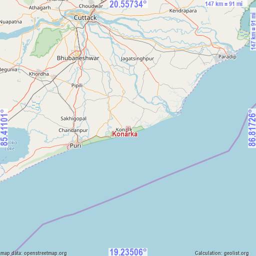
Konārka GPS coordinates[2]
19° 53' 51.288" North, 86° 6' 50.868" East
| Map corner | latitude | longitude |
|---|---|---|
| Upper-left | 20.55734°, | 85.41101° |
| Center: | 19.89758°, | 86.11413° |
| Lower-right: | 19.23506°, | 86.81726° |
| Map W x H: | 147×147 km | = 91.3×91.3mi |
| max Lat: | 34.9274° ⇑65.6% North |
| Konārka: | 19.89758° |
| min Lat: | ⇓34.4% South 8.09008° |
| min Long | Konārka | max Long |
| 68.82655° | 86.11413° | 96.81° |
| W 87.2%⇐ | ⇒12.8% E |
Elevation
Elevation of Konārka is 10 m = 33 ft, and this is 285.6 m = 937 ft below average elevation for this country.
| Max E: |
3681 m = 12077 ft | 96.4% |
| Avg. | 295.6 m = 970 ft | |
| Konārka | 10 m = 33 ft | |
Min E: |
1 m = 3 ft | 3.6% |
See also: India elevation on elevation.city.
Geographical zone
Konārka is located in North Torrid zone (between Equator and Tropic of Cancer). Distance of this Northern Tropic circle is 393.5 km =244.5 mi to North.| Distance of | km | miles | from Konārka |
|---|---|---|---|
| North Pole | 7794.7 | 4843.4 | to North |
| Arctic Circle | 5188.8 | 3224.2 | to North |
| Tropic Cancer | 393.5 | 244.5 | to North |
| Equator | 2212.4 | 1374.7 | to South |


Nearby cities:
15 places around Konārka: (largest is in red/bold)
• Bhubaneshwar
50.9 km =31.6 mi,  324°
324°
• Bānapur
99.6 km =61.9 mi,  262°
262°
• Bānki
81.2 km =50.5 mi,  311°
311°
• Cuttack
67.7 km =42.1 mi,  338°
338°
• Dhenkānāl
100.2 km =62.3 mi,  327°
327°
• Jagatsinghapur
40.3 km =25 mi,  8°
8°
• Jatani
51.5 km =32 mi,  304°
304°
• Kendrāparha
74.5 km =46.3 mi,  25°
25°
• Khurda
60.9 km =37.8 mi, 301°
• Nimāparha
21.2 km =13.2 mi, 327°
• Parādīp Garh
69.5 km =43.2 mi,  47°
47°
• Patāmundai
88.9 km =55.2 mi, 31°
• Pipili
38.1 km =23.7 mi, 309°
• Puri
32.2 km =20 mi,  249°
249°
• Āthagarh
85.7 km =53.3 mi, 323°
Sources, notices
• [Note1] Compared only with cities in India existing in our database
• [Src1] Map data: © OpenStreetMap contributors (CC-BY-SA)
• [Src2] Other city data from geonames.org with taken over terms of usage.
• [Src3] Geographical zone / Annual Mean Temperature by Robert A. Rohde @ Wikipedia
