Jājpur geodata
Jājpur (Odisha) is a populated place; located in India in Asia/Kolkata (GMT+5.5) time zone. With population of 42,157 people, there are 1048 cities with bigger population in this country. Compared to other cities in India, 62.2% of cities are located further ↑North; 87.8% of cities are located further ←West and 91.9% of cities have higher elevation than Jājpur. Note1


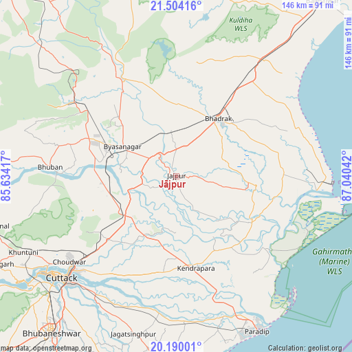
Jājpur GPS coordinates[2]
20° 50' 54.672" North, 86° 20' 14.244" East
| Map corner | latitude | longitude |
|---|---|---|
| Upper-left | 21.50416°, | 85.63417° |
| Center: | 20.84852°, | 86.33729° |
| Lower-right: | 20.19001°, | 87.04042° |
| Map W x H: | 146.1×146.1 km | = 90.8×90.8mi |
| max Lat: | 34.9274° ⇑62.2% North |
| Jājpur: | 20.84852° |
| min Lat: | ⇓37.8% South 8.09008° |
| min Long | Jājpur | max Long |
| 68.82655° | 86.33729° | 96.81° |
| W 87.8%⇐ | ⇒12.2% E |
Elevation
Elevation of Jājpur is 15 m = 49 ft, and this is 280.6 m = 921 ft below average elevation for this country.
| Max E: |
3681 m = 12077 ft | 91.9% |
| Avg. | 295.6 m = 970 ft | |
| Jājpur | 15 m = 49 ft | |
Min E: |
1 m = 3 ft | 8.1% |
See also: Jājpur elevation on elevation.city.
Geographical zone
Jājpur is located in North Torrid zone (between Equator and Tropic of Cancer). Distance of this Northern Tropic circle is 287.8 km =178.8 mi to North.| Distance of | km | miles | from Jājpur |
|---|---|---|---|
| North Pole | 7688.9 | 4777.7 | to North |
| Arctic Circle | 5083 | 3158.4 | to North |
| Tropic Cancer | 287.8 | 178.8 | to North |
| Equator | 2318.1 | 1440.4 | to South |


Nearby cities:
15 places around Jājpur: (largest is in red/bold)
• Bhadrakh
29.4 km =18.3 mi,  38°
38°
• Bhuban
52.5 km =32.6 mi,  274°
274°
• Bhubaneshwar
82.8 km =51.4 mi,  219°
219°
• Bāsudebpur
50.6 km =31.4 mi,  53°
53°
• Chāndbāli
42.8 km =26.6 mi,  100°
100°
• Cuttack
63.9 km =39.7 mi,  228°
228°
• Daitari
67.1 km =41.7 mi,  294°
294°
• Dhenkānāl
79.9 km =49.6 mi,  254°
254°
• Jagatsinghapur
68.1 km =42.3 mi,  194°
194°
• Kendrāparha
39.6 km =24.6 mi,  167°
167°
• Nīlgiri
81.6 km =50.7 mi,  33°
33°
• Parādīp Garh
65.6 km =40.8 mi,  154°
154°
• Patāmundai
38 km =23.6 mi,  142°
142°
• Soro
60.1 km =37.3 mi, 37°
• Āthagarh
82.2 km =51.1 mi,  243°
243°
Sources, notices
• [Note1] Compared only with cities in India existing in our database
• [Src1] Map data: © OpenStreetMap contributors (CC-BY-SA)
• [Src2] Other city data from geonames.org with taken over terms of usage.
• [Src3] Geographical zone / Annual Mean Temperature by Robert A. Rohde @ Wikipedia
