Jatani geodata
Jatani (Odisha) is a populated place; located in India in Asia/Kolkata (GMT+5.5) time zone. With population of 56,003 people, there are 794 cities with bigger population in this country. Compared to other cities in India, 64.6% of cities are located further ↑North; 86.2% of cities are located further ←West and 82.6% of cities have higher elevation than Jatani. Note1


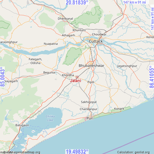
Jatani GPS coordinates[2]
20° 9' 35.1" North, 85° 42' 26.712" East
| Map corner | latitude | longitude |
|---|---|---|
| Upper-left | 20.81839°, | 85.0043° |
| Center: | 20.15975°, | 85.70742° |
| Lower-right: | 19.49832°, | 86.41055° |
| Map W x H: | 146.8×146.8 km | = 91.2×91.2mi |
| max Lat: | 34.9274° ⇑64.6% North |
| Jatani: | 20.15975° |
| min Lat: | ⇓35.4% South 8.09008° |
| min Long | Jatani | max Long |
| 68.82655° | 85.70742° | 96.81° |
| W 86.2%⇐ | ⇒13.8% E |
Elevation
Elevation of Jatani is 38 m = 125 ft, and this is 257.6 m = 845 ft below average elevation for this country.
| Max E: |
3681 m = 12077 ft | 82.6% |
| Avg. | 295.6 m = 970 ft | |
| Jatani | 38 m = 125 ft | |
Min E: |
1 m = 3 ft | 17.4% |
See also: Jatani elevation on elevation.city.
Geographical zone
Jatani is located in North Torrid zone (between Equator and Tropic of Cancer). Distance of this Northern Tropic circle is 364.4 km =226.4 mi to North.| Distance of | km | miles | from Jatani |
|---|---|---|---|
| North Pole | 7765.5 | 4825.3 | to North |
| Arctic Circle | 5159.6 | 3206 | to North |
| Tropic Cancer | 364.4 | 226.4 | to North |
| Equator | 2241.6 | 1392.9 | to South |


Nearby cities:
15 places around Jatani: (largest is in red/bold)
• Bhubaneshwar
18.2 km =11.3 mi,  46°
46°
• Bālugaon
62 km =38.5 mi,  271°
271°
• Bānapur
70.3 km =43.7 mi,  232°
232°
• Bānki
30.6 km =19 mi,  322°
322°
• Cuttack
38.4 km =23.9 mi,  27°
27°
• Dhenkānāl
56.5 km =35.1 mi,  348°
348°
• Jagatsinghapur
49.5 km =30.8 mi,  77°
77°
• Kantilo
58.2 km =36.2 mi,  292°
292°
• Khurda
9.8 km =6.1 mi, 285°
• Konārka
51.5 km =32 mi,  124°
124°
• Nayāgarh
63.9 km =39.7 mi, 266°
• Nimāparha
33 km =20.5 mi,  110°
110°
• Pipili
13.9 km =8.6 mi, 111°
• Puri
42 km =26.1 mi,  163°
163°
• Āthagarh
40.9 km =25.4 mi, 348°
Sources, notices
• [Note1] Compared only with cities in India existing in our database
• [Src1] Map data: © OpenStreetMap contributors (CC-BY-SA)
• [Src2] Other city data from geonames.org with taken over terms of usage.
• [Src3] Geographical zone / Annual Mean Temperature by Robert A. Rohde @ Wikipedia
