Cuttack geodata
Cuttack (Odisha) is a populated place; located in India in Asia/Kolkata (GMT+5.5) time zone. With population of 580,000 people, there are 74 cities with bigger population in this country. Compared to other cities in India, 63.8% of cities are located further ↑North; 86.6% of cities are located further ←West and 85.1% of cities have higher elevation than Cuttack. Note1


Cuttack GPS coordinates[2]
20° 27' 53.892" North, 85° 52' 45.372" East
| Map corner | latitude | longitude |
|---|---|---|
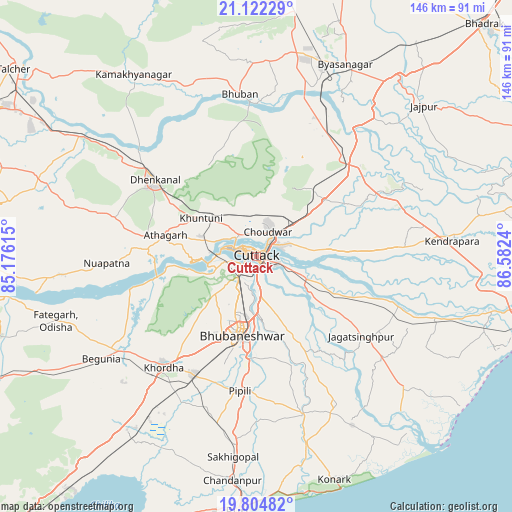
| Upper-left | 21.12229°, | 85.17615° |
| Center: | 20.46497°, | 85.87927° |
| Lower-right: | 19.80482°, | 86.5824° |
| Map W x H: | 146.5×146.5 km | = 91×91mi |
| max Lat: | 34.9274° ⇑63.8% North |
| Cuttack: | 20.46497° |
| min Lat: | ⇓36.2% South 8.09008° |
| min Long | Cuttack | max Long |
| 68.82655° | 85.87927° | 96.81° |
| W 86.6%⇐ | ⇒13.4% E |
Elevation
Elevation of Cuttack is 30 m = 98 ft, and this is 265.6 m = 871 ft below average elevation for this country.
| Max E: |
3681 m = 12077 ft | 85.1% |
| Avg. | 295.6 m = 970 ft | |
| Cuttack | 30 m = 98 ft | |
Min E: |
1 m = 3 ft | 14.9% |
See also: Cuttack elevation on elevation.city.
Geographical zone
Cuttack is located in North Torrid zone (between Equator and Tropic of Cancer). Distance of this Northern Tropic circle is 330.4 km =205.3 mi to North.| Distance of | km | miles | from Cuttack |
|---|---|---|---|
| North Pole | 7731.6 | 4804.2 | to North |
| Arctic Circle | 5125.7 | 3185 | to North |
| Tropic Cancer | 330.4 | 205.3 | to North |
| Equator | 2275.5 | 1413.9 | to South |


Nearby cities:
15 places around Cuttack: (largest is in red/bold)
• Bhuban
46.6 km =29 mi,  354°
354°
• Bhubaneshwar
21.9 km =13.6 mi,  192°
192°
• Bānki
37.7 km =23.4 mi,  255°
255°
• Daitari
71.9 km =44.7 mi, 349°
• Dhenkānāl
36.4 km =22.6 mi,  306°
306°
• Jagatsinghapur
38.3 km =23.8 mi,  127°
127°
• Jatani
38.4 km =23.9 mi,  207°
207°
• Jājpur
63.9 km =39.7 mi,  48°
48°
• Kendrāparha
56.7 km =35.2 mi,  85°
85°
• Khurda
41.7 km =25.9 mi,  221°
221°
• Konārka
67.7 km =42.1 mi,  158°
158°
• Kāmākhyānagar
62.7 km =39 mi,  326°
326°
• Nimāparha
47.1 km =29.3 mi, 163°
• Pipili
39.4 km =24.5 mi, 187°
• Āthagarh
26.7 km =16.6 mi,  283°
283°
Sources, notices
• [Note1] Compared only with cities in India existing in our database
• [Src1] Map data: © OpenStreetMap contributors (CC-BY-SA)
• [Src2] Other city data from geonames.org with taken over terms of usage.
• [Src3] Geographical zone / Annual Mean Temperature by Robert A. Rohde @ Wikipedia
