Karnāl geodata
Karnāl (Haryana) is a populated place; located in India in Asia/Kolkata (GMT+5.5) time zone. With population of 225,049 people, there are 190 cities with bigger population in this country. Compared to other cities in India, 91.8% of cities are located further ↓South; 63.3% of cities are located further →East and 60.5% of cities have lower elevation than Karnāl. Note1


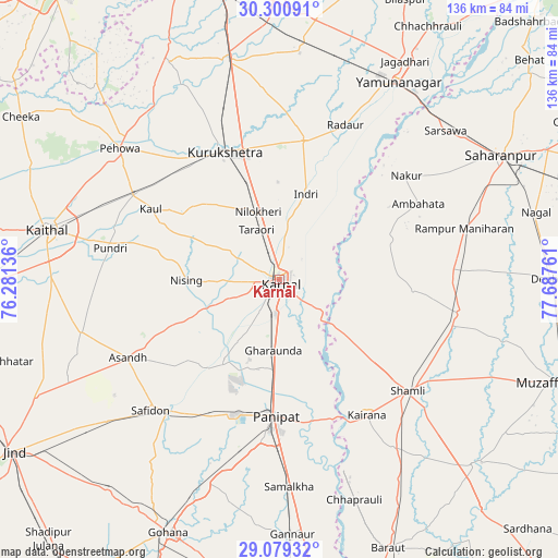
Karnāl GPS coordinates[2]
29° 41' 31.092" North, 76° 59' 4.128" East
| Map corner | latitude | longitude |
|---|---|---|
| Upper-left | 30.30091°, | 76.28136° |
| Center: | 29.69197°, | 76.98448° |
| Lower-right: | 29.07932°, | 77.68761° |
| Map W x H: | 135.8×135.8 km | = 84.4×84.4mi |
| max Lat: | 34.9274° ⇑8.2% North |
| Karnāl: | 29.69197° |
| min Lat: | ⇓91.8% South 8.09008° |
| min Long | Karnāl | max Long |
| 68.82655° | 76.98448° | 96.81° |
| W 36.7%⇐ | ⇒63.3% E |
Elevation
Elevation of Karnāl is 255 m = 837 ft, and this is 40.6 m = 133 ft below average elevation for this country.
| Max E: |
3681 m = 12077 ft | 39.5% |
| Avg. | 295.6 m = 970 ft | |
| Karnāl | 255 m = 837 ft | |
Min E: |
1 m = 3 ft | 60.5% |
See also: Karnāl elevation on elevation.city.
Geographical zone
Karnāl is located in North temperate zone (between Tropic of Cancer and the Arctic Circle). Distance of this Northern Tropic circle is 695.5 km =432.2 mi to South.| Distance of | km | miles | from Karnāl |
|---|---|---|---|
| North Pole | 6705.6 | 4166.7 | to North |
| Arctic Circle | 4099.7 | 2547.4 | to North |
| Tropic Cancer | 695.5 | 432.2 | to South |
| Equator | 3301.4 | 2051.4 | to South |


Nearby cities:
15 places around Karnāl: (largest is in red/bold)
• Ambahta
38.6 km =24 mi,  61°
61°
• Gangoh
28.7 km =17.8 mi,  70°
70°
• Garhi Pūkhta
35.1 km =21.8 mi,  116°
116°
• Gharaunda
17.3 km =10.7 mi,  184°
184°
• Indri
22.1 km =13.7 mi,  19°
19°
• Jhinjhāna
30 km =18.6 mi,  129°
129°
• Kairāna
39.3 km =24.4 mi,  147°
147°
• Lādwa
34 km =21.1 mi,  9°
9°
• Nakūr
39.9 km =24.8 mi,  50°
50°
• Nīlokheri
16.9 km =10.5 mi,  342°
342°
• Pānīpat
33.9 km =21.1 mi, 182°
• Radaur
40.6 km =25.2 mi, 23°
• Thānesar
34.6 km =21.5 mi,  334°
334°
• Titron
32.9 km =20.4 mi,  94°
94°
• Ūn
28.8 km =17.9 mi,  114°
114°
Sources, notices
• [Note1] Compared only with cities in India existing in our database
• [Src1] Map data: © OpenStreetMap contributors (CC-BY-SA)
• [Src2] Other city data from geonames.org with taken over terms of usage.
• [Src3] Geographical zone / Annual Mean Temperature by Robert A. Rohde @ Wikipedia
