Ambahta geodata
Ambahta (Uttar Pradesh) is a populated place; located in India in Asia/Kolkata (GMT+5.5) time zone. With population of 14,303 people, there are 2530 cities with bigger population in this country. Compared to other cities in India, 92.5% of cities are located further ↓South; 59.1% of cities are located further →East and 62.7% of cities have lower elevation than Ambahta. Note1


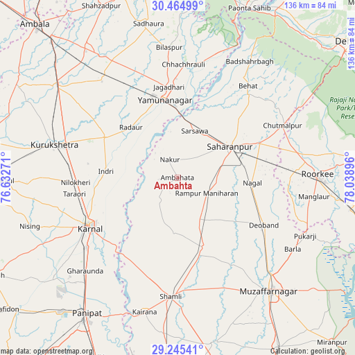
Ambahta GPS coordinates[2]
29° 51' 25.416" North, 77° 20' 8.988" East
| Map corner | latitude | longitude |
|---|---|---|
| Upper-left | 30.46499°, | 76.63271° |
| Center: | 29.85706°, | 77.33583° |
| Lower-right: | 29.24541°, | 78.03896° |
| Map W x H: | 135.6×135.6 km | = 84.3×84.3mi |
| max Lat: | 34.9274° ⇑7.5% North |
| Ambahta: | 29.85706° |
| min Lat: | ⇓92.5% South 8.09008° |
| min Long | Ambahta | max Long |
| 68.82655° | 77.33583° | 96.81° |
| W 40.9%⇐ | ⇒59.1% E |
Elevation
Elevation of Ambahta is 269 m = 883 ft, and this is 26.6 m = 87 ft below average elevation for this country.
| Max E: |
3681 m = 12077 ft | 37.3% |
| Avg. | 295.6 m = 970 ft | |
| Ambahta | 269 m = 883 ft | |
Min E: |
1 m = 3 ft | 62.7% |
See also: India elevation on elevation.city.
Geographical zone
Ambahta is located in North temperate zone (between Tropic of Cancer and the Arctic Circle). Distance of this Northern Tropic circle is 713.9 km =443.6 mi to South.| Distance of | km | miles | from Ambahta |
|---|---|---|---|
| North Pole | 6687.3 | 4155.3 | to North |
| Arctic Circle | 4081.4 | 2536.1 | to North |
| Tropic Cancer | 713.9 | 443.6 | to South |
| Equator | 3319.8 | 2062.8 | to South |


Nearby cities:
15 places around Ambahta: (largest is in red/bold)
• Būriya
33.7 km =20.9 mi,  3°
3°
• Gangoh
11 km =6.8 mi,  219°
219°
• Garhi Pūkhta
34.3 km =21.3 mi,  184°
184°
• Indri
26.7 km =16.6 mi,  275°
275°
• Jalālābad
28.3 km =17.6 mi,  159°
159°
• Lādwa
31.8 km =19.8 mi,  298°
298°
• Nakūr
7.6 km =4.7 mi,  336°
336°
• Nanauta
17.9 km =11.1 mi,  153°
153°
• Radaur
25.9 km =16.1 mi,  316°
316°
• Rāmpur
12.6 km =7.8 mi,  116°
116°
• Sahāranpur
23.6 km =14.7 mi,  58°
58°
• Thāna Bhawan
31.2 km =19.4 mi,  165°
165°
• Titron
21 km =13 mi, 183°
• Yamunānagar
30.5 km =19 mi,  350°
350°
• Ūn
31.3 km =19.4 mi,  194°
194°
Sources, notices
• [Note1] Compared only with cities in India existing in our database
• [Src1] Map data: © OpenStreetMap contributors (CC-BY-SA)
• [Src2] Other city data from geonames.org with taken over terms of usage.
• [Src3] Geographical zone / Annual Mean Temperature by Robert A. Rohde @ Wikipedia
