Lādwa geodata
Lādwa (Haryana) is a populated place; located in India in Asia/Kolkata (GMT+5.5) time zone. With population of 23,565 people, there are 1793 cities with bigger population in this country. Compared to other cities in India, 92.8% of cities are located further ↓South; 62.6% of cities are located further →East and 62.3% of cities have lower elevation than Lādwa. Note1


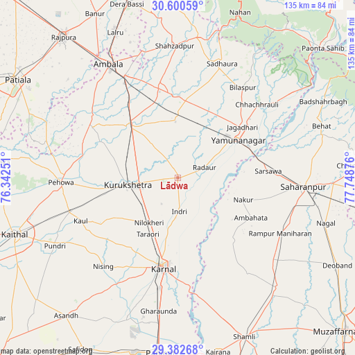
Lādwa GPS coordinates[2]
29° 59' 36.6" North, 77° 2' 44.268" East
| Map corner | latitude | longitude |
|---|---|---|
| Upper-left | 30.60059°, | 76.34251° |
| Center: | 29.9935°, | 77.04563° |
| Lower-right: | 29.38268°, | 77.74876° |
| Map W x H: | 135.4×135.4 km | = 84.1×84.1mi |
| max Lat: | 34.9274° ⇑7.2% North |
| Lādwa: | 29.9935° |
| min Lat: | ⇓92.8% South 8.09008° |
| min Long | Lādwa | max Long |
| 68.82655° | 77.04563° | 96.81° |
| W 37.4%⇐ | ⇒62.6% E |
Elevation
Elevation of Lādwa is 266 m = 873 ft, and this is 29.6 m = 97 ft below average elevation for this country.
| Max E: |
3681 m = 12077 ft | 37.7% |
| Avg. | 295.6 m = 970 ft | |
| Lādwa | 266 m = 873 ft | |
Min E: |
1 m = 3 ft | 62.3% |
See also: India elevation on elevation.city.
Geographical zone
Lādwa is located in North temperate zone (between Tropic of Cancer and the Arctic Circle). Distance of this Northern Tropic circle is 729 km =453 mi to South.| Distance of | km | miles | from Lādwa |
|---|---|---|---|
| North Pole | 6672.1 | 4145.8 | to North |
| Arctic Circle | 4066.2 | 2526.6 | to North |
| Tropic Cancer | 729 | 453 | to South |
| Equator | 3335 | 2072.3 | to South |


Nearby cities:
15 places around Lādwa: (largest is in red/bold)
• Ambahta
31.8 km =19.8 mi,  118°
118°
• Bilāspur
42.6 km =26.5 mi,  35°
35°
• Būriya
35.3 km =21.9 mi,  58°
58°
• Chhachhrauli
41.2 km =25.6 mi,  47°
47°
• Gangoh
31.7 km =19.7 mi,  138°
138°
• Indri
12.7 km =7.9 mi,  173°
173°
• Jagādhri
31.5 km =19.6 mi, 52°
• Karnāl
34 km =21.1 mi,  189°
189°
• Mustafābād
25.2 km =15.7 mi,  23°
23°
• Nakūr
26.2 km =16.3 mi,  108°
108°
• Nīlokheri
20.6 km =12.8 mi,  212°
212°
• Radaur
10.9 km =6.8 mi,  69°
69°
• Shāhābād
25.7 km =16 mi,  318°
318°
• Thānesar
20.7 km =12.9 mi,  263°
263°
• Yamunānagar
27.4 km =17 mi, 56°
Sources, notices
• [Note1] Compared only with cities in India existing in our database
• [Src1] Map data: © OpenStreetMap contributors (CC-BY-SA)
• [Src2] Other city data from geonames.org with taken over terms of usage.
• [Src3] Geographical zone / Annual Mean Temperature by Robert A. Rohde @ Wikipedia
