Thānesar geodata
Thānesar (Haryana) is a populated place; located in India in Asia/Kolkata (GMT+5.5) time zone. With population of 138,279 people, there are 314 cities with bigger population in this country. Compared to other cities in India, 92.7% of cities are located further ↓South; 64.9% of cities are located further →East and 61.3% of cities have lower elevation than Thānesar. Note1


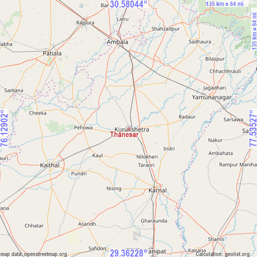
Thānesar GPS coordinates[2]
29° 58' 23.628" North, 76° 49' 55.704" East
| Map corner | latitude | longitude |
|---|---|---|
| Upper-left | 30.58044°, | 76.12902° |
| Center: | 29.97323°, | 76.83214° |
| Lower-right: | 29.36228°, | 77.53527° |
| Map W x H: | 135.4×135.4 km | = 84.1×84.1mi |
| max Lat: | 34.9274° ⇑7.3% North |
| Thānesar: | 29.97323° |
| min Lat: | ⇓92.7% South 8.09008° |
| min Long | Thānesar | max Long |
| 68.82655° | 76.83214° | 96.81° |
| W 35.1%⇐ | ⇒64.9% E |
Elevation
Elevation of Thānesar is 260 m = 853 ft, and this is 35.6 m = 117 ft below average elevation for this country.
| Max E: |
3681 m = 12077 ft | 38.7% |
| Avg. | 295.6 m = 970 ft | |
| Thānesar | 260 m = 853 ft | |
Min E: |
1 m = 3 ft | 61.3% |
See also: Thānesar elevation on elevation.city.
Geographical zone
Thānesar is located in North temperate zone (between Tropic of Cancer and the Arctic Circle). Distance of this Northern Tropic circle is 726.8 km =451.6 mi to South.| Distance of | km | miles | from Thānesar |
|---|---|---|---|
| North Pole | 6674.4 | 4147.3 | to North |
| Arctic Circle | 4068.5 | 2528 | to North |
| Tropic Cancer | 726.8 | 451.6 | to South |
| Equator | 3332.7 | 2070.8 | to South |


Nearby cities:
15 places around Thānesar: (largest is in red/bold)
• Ambāla
43.2 km =26.8 mi,  355°
355°
• Gangoh
46.8 km =29.1 mi,  117°
117°
• Ghanaur
45.1 km =28 mi,  331°
331°
• Indri
24.3 km =15.1 mi, 115°
• Kaithal
45.9 km =28.5 mi,  245°
245°
• Karnāl
34.6 km =21.5 mi,  154°
154°
• Lādwa
20.7 km =12.9 mi,  83°
83°
• Mustafābād
39.7 km =24.7 mi,  50°
50°
• Nakūr
45.9 km =28.5 mi,  97°
97°
• Nīlokheri
18 km =11.2 mi, 147°
• Pehowa
24.1 km =15 mi,  271°
271°
• Pūndri
35.3 km =21.9 mi,  227°
227°
• Radaur
31.4 km =19.5 mi, 78°
• Shāhābād
21.9 km =13.6 mi,  9°
9°
• Yamunānagar
46.7 km =29 mi,  68°
68°
Sources, notices
• [Note1] Compared only with cities in India existing in our database
• [Src1] Map data: © OpenStreetMap contributors (CC-BY-SA)
• [Src2] Other city data from geonames.org with taken over terms of usage.
• [Src3] Geographical zone / Annual Mean Temperature by Robert A. Rohde @ Wikipedia
