Radaur geodata
Radaur (Haryana) is a populated place; located in India in Asia/Kolkata (GMT+5.5) time zone. With population of 12,328 people, there are 2715 cities with bigger population in this country. Compared to other cities in India, 92.9% of cities are located further ↓South; 61.5% of cities are located further →East and 62.8% of cities have lower elevation than Radaur. Note1


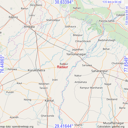
Radaur GPS coordinates[2]
30° 1' 37.416" North, 77° 9' 6.372" East
| Map corner | latitude | longitude |
|---|---|---|
| Upper-left | 30.63394°, | 76.44865° |
| Center: | 30.02706°, | 77.15177° |
| Lower-right: | 29.41644°, | 77.8549° |
| Map W x H: | 135.4×135.4 km | = 84.1×84.1mi |
| max Lat: | 34.9274° ⇑7.1% North |
| Radaur: | 30.02706° |
| min Lat: | ⇓92.9% South 8.09008° |
| min Long | Radaur | max Long |
| 68.82655° | 77.15177° | 96.81° |
| W 38.5%⇐ | ⇒61.5% E |
Elevation
Elevation of Radaur is 270 m = 886 ft, and this is 25.6 m = 84 ft below average elevation for this country.
| Max E: |
3681 m = 12077 ft | 37.2% |
| Avg. | 295.6 m = 970 ft | |
| Radaur | 270 m = 886 ft | |
Min E: |
1 m = 3 ft | 62.8% |
See also: India elevation on elevation.city.
Geographical zone
Radaur is located in North temperate zone (between Tropic of Cancer and the Arctic Circle). Distance of this Northern Tropic circle is 732.8 km =455.3 mi to South.| Distance of | km | miles | from Radaur |
|---|---|---|---|
| North Pole | 6668.4 | 4143.6 | to North |
| Arctic Circle | 4062.5 | 2524.3 | to North |
| Tropic Cancer | 732.8 | 455.3 | to South |
| Equator | 3338.7 | 2074.6 | to South |


Nearby cities:
15 places around Radaur: (largest is in red/bold)
• Ambahta
25.9 km =16.1 mi,  136°
136°
• Bilāspur
34.2 km =21.3 mi,  25°
25°
• Būriya
24.7 km =15.3 mi,  53°
53°
• Chhachhrauli
31.4 km =19.5 mi,  39°
39°
• Gangoh
29.5 km =18.3 mi,  158°
158°
• Indri
18.6 km =11.6 mi,  208°
208°
• Jagādhri
21.4 km =13.3 mi, 43°
• Lādwa
10.9 km =6.8 mi,  249°
249°
• Mustafābād
19.5 km =12.1 mi,  359°
359°
• Nakūr
18.9 km =11.7 mi,  129°
129°
• Nīlokheri
29.9 km =18.6 mi,  225°
225°
• Rāmpur
38 km =23.6 mi, 130°
• Shāhābād
31.3 km =19.4 mi,  300°
300°
• Thānesar
31.4 km =19.5 mi,  258°
258°
• Yamunānagar
16.9 km =10.5 mi, 48°
Sources, notices
• [Note1] Compared only with cities in India existing in our database
• [Src1] Map data: © OpenStreetMap contributors (CC-BY-SA)
• [Src2] Other city data from geonames.org with taken over terms of usage.
• [Src3] Geographical zone / Annual Mean Temperature by Robert A. Rohde @ Wikipedia
