Sattur geodata
Sattur (Tamil Nadu) is a populated place; located in India in Asia/Kolkata (GMT+5.5) time zone. With population of 31,856 people, there are 1367 cities with bigger population in this country. Compared to other cities in India, 98% of cities are located further ↑North; 52.1% of cities are located further →East and 75.6% of cities have higher elevation than Sattur. Note1


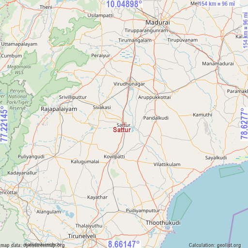
Sattur GPS coordinates[2]
9° 21' 21.312" North, 77° 55' 28.452" East
| Map corner | latitude | longitude |
|---|---|---|
| Upper-left | 10.04898°, | 77.22145° |
| Center: | 9.35592°, | 77.92457° |
| Lower-right: | 8.66147°, | 78.6277° |
| Map W x H: | 154.3×154.3 km | = 95.9×95.9mi |
| max Lat: | 34.9274° ⇑98% North |
| Sattur: | 9.35592° |
| min Lat: | ⇓2% South 8.09008° |
| min Long | Sattur | max Long |
| 68.82655° | 77.92457° | 96.81° |
| W 47.9%⇐ | ⇒52.1% E |
Elevation
Elevation of Sattur is 66 m = 217 ft, and this is 229.6 m = 753 ft below average elevation for this country.
| Max E: |
3681 m = 12077 ft | 75.6% |
| Avg. | 295.6 m = 970 ft | |
| Sattur | 66 m = 217 ft | |
Min E: |
1 m = 3 ft | 24.4% |
See also: India elevation on elevation.city.
Geographical zone
Sattur is located in North Torrid zone (between Equator and Tropic of Cancer). Distance of Equator is 1040.3 km =646.4 mi to South.| Distance of | km | miles | from Sattur |
|---|---|---|---|
| North Pole | 8966.8 | 5571.7 | to North |
| Arctic Circle | 6360.9 | 3952.5 | to North |
| Tropic Cancer | 1565.6 | 972.8 | to North |
| Equator | 1040.3 | 646.4 | to South |


Nearby cities:
15 places around Sattur: (largest is in red/bold)
• Aruppukkottai
25.4 km =15.8 mi,  47°
47°
• Cholapuram
39.1 km =24.3 mi,  269°
269°
• Elāyirampannai
14.5 km =9 mi,  228°
228°
• Ettaiyapuram
24.6 km =15.3 mi,  162°
162°
• Kadambūr
40.5 km =25.2 mi,  189°
189°
• Kallupatti
40.6 km =25.2 mi,  351°
351°
• Kalugumalai
33.2 km =20.6 mi, 226°
• Kariapatti
40.4 km =25.1 mi,  28°
28°
• Kovilpatti
21.3 km =13.2 mi,  196°
196°
• Pudūr
24.5 km =15.2 mi,  106°
106°
• Sivakasi
17.4 km =10.8 mi,  306°
306°
• Srivilliputhur
36.4 km =22.6 mi,  298°
298°
• Tiruttangal
17.3 km =10.7 mi,  324°
324°
• Vilattikulam
36.4 km =22.6 mi,  133°
133°
• Virudunagar
25.7 km =16 mi,  8°
8°
Sources, notices
• [Note1] Compared only with cities in India existing in our database
• [Src1] Map data: © OpenStreetMap contributors (CC-BY-SA)
• [Src2] Other city data from geonames.org with taken over terms of usage.
• [Src3] Geographical zone / Annual Mean Temperature by Robert A. Rohde @ Wikipedia
