Sangamner geodata
Sangamner (Maharashtra) is a populated place; located in India in Asia/Kolkata (GMT+5.5) time zone. With population of 67,309 people, there are 645 cities with bigger population in this country. Compared to other cities in India, 66.8% of cities are located further ↑North; 88.3% of cities are located further →East and 85.5% of cities have lower elevation than Sangamner. Note1


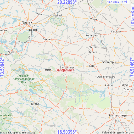
Sangamner GPS coordinates[2]
19° 34' 4.224" North, 74° 12' 41.544" East
| Map corner | latitude | longitude |
|---|---|---|
| Upper-left | 20.22898°, | 73.50842° |
| Center: | 19.56784°, | 74.21154° |
| Lower-right: | 18.90398°, | 74.91467° |
| Map W x H: | 147.3×147.3 km | = 91.5×91.5mi |
| max Lat: | 34.9274° ⇑66.8% North |
| Sangamner: | 19.56784° |
| min Lat: | ⇓33.2% South 8.09008° |
| min Long | Sangamner | max Long |
| 68.82655° | 74.21154° | 96.81° |
| W 11.7%⇐ | ⇒88.3% E |
Elevation
Elevation of Sangamner is 557 m = 1827 ft, and this is 261.4 m = 858 ft above average elevation for this country.
| Max E: |
3681 m = 12077 ft | 14.5% |
| Sangamner | 557 m 1827 ft | |
| Avg. | 295.6 m = 970 ft | |
Min E: |
1 m = 3 ft | 85.5% |
See also: Sangamner elevation on elevation.city.
Geographical zone
Sangamner is located in North Torrid zone (between Equator and Tropic of Cancer). Distance of this Northern Tropic circle is 430.2 km =267.3 mi to North.| Distance of | km | miles | from Sangamner |
|---|---|---|---|
| North Pole | 7831.3 | 4866.1 | to North |
| Arctic Circle | 5225.4 | 3246.9 | to North |
| Tropic Cancer | 430.2 | 267.3 | to North |
| Equator | 2175.7 | 1351.9 | to South |


Nearby cities:
15 places around Sangamner: (largest is in red/bold)
• Deolāli
57.5 km =35.7 mi,  316°
316°
• Ghoti Budrukh
63.3 km =39.3 mi,  285°
285°
• Igatpuri
69.4 km =43.1 mi,  281°
281°
• Junnar
53.3 km =33.1 mi,  221°
221°
• Kalamb
64.1 km =39.8 mi,  204°
204°
• Kopargaon
44.6 km =27.7 mi,  38°
38°
• Lāsalgaon
64 km =39.8 mi,  2°
2°
• Manchar
68.7 km =42.7 mi, 204°
• Nashik
64.9 km =40.3 mi, 317°
• Ozar
65.7 km =40.8 mi,  333°
333°
• Rāhuri
50 km =31.1 mi,  113°
113°
• Shirdi
35.5 km =22.1 mi,  51°
51°
• Sinnar
38 km =23.6 mi, 324°
• Vaijāpur
67.1 km =41.7 mi, 53°
• Yeola
60.2 km =37.4 mi,  28°
28°
Sources, notices
• [Note1] Compared only with cities in India existing in our database
• [Src1] Map data: © OpenStreetMap contributors (CC-BY-SA)
• [Src2] Other city data from geonames.org with taken over terms of usage.
• [Src3] Geographical zone / Annual Mean Temperature by Robert A. Rohde @ Wikipedia
