Iringal geodata
Iringal (Kerala) is a populated place; located in India in Asia/Kolkata (GMT+5.5) time zone. With population of 24,318 people, there are 1746 cities with bigger population in this country. Compared to other cities in India, 91.1% of cities are located further ↑North; 77.5% of cities are located further →East and 86.8% of cities have higher elevation than Iringal. Note1


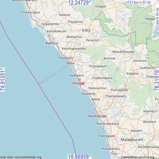
Iringal GPS coordinates[2]
11° 33' 33.444" North, 75° 36' 59.868" East
| Map corner | latitude | longitude |
|---|---|---|
| Upper-left | 12.24729°, | 74.91351° |
| Center: | 11.55929°, | 75.61663° |
| Lower-right: | 10.86959°, | 76.31976° |
| Map W x H: | 153.2×153.2 km | = 95.2×95.2mi |
| max Lat: | 34.9274° ⇑91.1% North |
| Iringal: | 11.55929° |
| min Lat: | ⇓8.9% South 8.09008° |
| min Long | Iringal | max Long |
| 68.82655° | 75.61663° | 96.81° |
| W 22.5%⇐ | ⇒77.5% E |
Elevation
Elevation of Iringal is 25 m = 82 ft, and this is 270.6 m = 888 ft below average elevation for this country.
| Max E: |
3681 m = 12077 ft | 86.8% |
| Avg. | 295.6 m = 970 ft | |
| Iringal | 25 m = 82 ft | |
Min E: |
1 m = 3 ft | 13.2% |
See also: India elevation on elevation.city.
Geographical zone
Iringal is located in North Torrid zone (between Equator and Tropic of Cancer). Distance of Equator is 1285.3 km =798.6 mi to South.| Distance of | km | miles | from Iringal |
|---|---|---|---|
| North Pole | 8721.8 | 5419.5 | to North |
| Arctic Circle | 6115.9 | 3800.2 | to North |
| Tropic Cancer | 1320.6 | 820.6 | to North |
| Equator | 1285.3 | 798.6 | to South |


Nearby cities:
15 places around Iringal: (largest is in red/bold)
• Badagara
5.7 km =3.5 mi,  318°
318°
• Beypore
47.8 km =29.7 mi,  154°
154°
• Dharmadam
29.2 km =18.1 mi,  325°
325°
• Kannavam
32.1 km =19.9 mi,  8°
8°
• Kannur
44.4 km =27.6 mi, 320°
• Kozhikode
38.9 km =24.2 mi, 152°
• Kunnamangalam
40.1 km =24.9 mi,  134°
134°
• Mahē
18.2 km =11.3 mi, 330°
• Mattanur
41.5 km =25.8 mi,  353°
353°
• Mavoor
46.1 km =28.6 mi, 134°
• Muluppilagadu
32.1 km =19.9 mi, 325°
• Naduvannūr
19 km =11.8 mi,  114°
114°
• Nādāpuram
14.5 km =9 mi,  16°
16°
• Perya
40 km =24.9 mi,  40°
40°
• Tellicherry
24.9 km =15.5 mi, 327°
Sources, notices
• [Note1] Compared only with cities in India existing in our database
• [Src1] Map data: © OpenStreetMap contributors (CC-BY-SA)
• [Src2] Other city data from geonames.org with taken over terms of usage.
• [Src3] Geographical zone / Annual Mean Temperature by Robert A. Rohde @ Wikipedia
