Naduvannūr geodata
Naduvannūr (Kerala) is a populated place; located in India in Asia/Kolkata (GMT+5.5) time zone. With population of 24,648 people, there are 1729 cities with bigger population in this country. Compared to other cities in India, 91.3% of cities are located further ↑North; 76% of cities are located further →East and 88.9% of cities have higher elevation than Naduvannūr. Note1


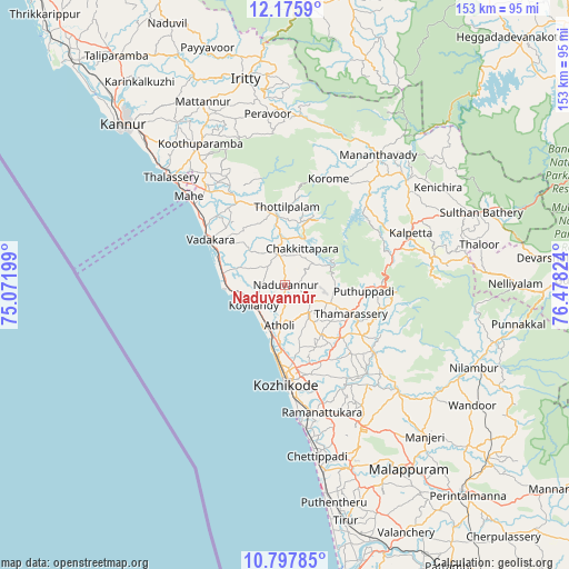
Naduvannūr GPS coordinates[2]
11° 29' 15.792" North, 75° 46' 30.396" East
| Map corner | latitude | longitude |
|---|---|---|
| Upper-left | 12.1759°, | 75.07199° |
| Center: | 11.48772°, | 75.77511° |
| Lower-right: | 10.79785°, | 76.47824° |
| Map W x H: | 153.2×153.2 km | = 95.2×95.2mi |
| max Lat: | 34.9274° ⇑91.3% North |
| Naduvannūr: | 11.48772° |
| min Lat: | ⇓8.7% South 8.09008° |
| min Long | Naduvannūr | max Long |
| 68.82655° | 75.77511° | 96.81° |
| W 24%⇐ | ⇒76% E |
Elevation
Elevation of Naduvannūr is 20 m = 66 ft, and this is 275.6 m = 904 ft below average elevation for this country.
| Max E: |
3681 m = 12077 ft | 88.9% |
| Avg. | 295.6 m = 970 ft | |
| Naduvannūr | 20 m = 66 ft | |
Min E: |
1 m = 3 ft | 11.1% |
See also: India elevation on elevation.city.
Geographical zone
Naduvannūr is located in North Torrid zone (between Equator and Tropic of Cancer). Distance of Equator is 1277.3 km =793.7 mi to South.| Distance of | km | miles | from Naduvannūr |
|---|---|---|---|
| North Pole | 8729.7 | 5424.4 | to North |
| Arctic Circle | 6123.9 | 3805.2 | to North |
| Tropic Cancer | 1328.6 | 825.6 | to North |
| Equator | 1277.3 | 793.7 | to South |


Nearby cities:
15 places around Naduvannūr: (largest is in red/bold)
• Badagara
24.4 km =15.2 mi,  300°
300°
• Beypore
35.3 km =21.9 mi,  174°
174°
• Dharmadam
46.5 km =28.9 mi,  313°
313°
• Ferokh
35 km =21.7 mi, 168°
• Iringal
19 km =11.8 mi,  294°
294°
• Kalpatta
36.2 km =22.5 mi,  68°
68°
• Kannavam
41.5 km =25.8 mi,  342°
342°
• Kozhikode
26.7 km =16.6 mi,  178°
178°
• Kunnamangalam
23.2 km =14.4 mi,  151°
151°
• Mahē
35.4 km =22 mi, 312°
• Mavoor
29 km =18 mi, 147°
• Nādāpuram
25.5 km =15.8 mi,  329°
329°
• Panamaram
43 km =26.7 mi,  49°
49°
• Perya
39.4 km =24.5 mi,  12°
12°
• Tellicherry
42.2 km =26.2 mi, 313°
Sources, notices
• [Note1] Compared only with cities in India existing in our database
• [Src1] Map data: © OpenStreetMap contributors (CC-BY-SA)
• [Src2] Other city data from geonames.org with taken over terms of usage.
• [Src3] Geographical zone / Annual Mean Temperature by Robert A. Rohde @ Wikipedia
