Mahē geodata
Mahē (Kerala) is a populated place; located in India in Asia/Kolkata (GMT+5.5) time zone. With population of 38,183 people, there are 1150 cities with bigger population in this country. Compared to other cities in India, 90.6% of cities are located further ↑North; 78.3% of cities are located further →East and 88.1% of cities have higher elevation than Mahē. Note1


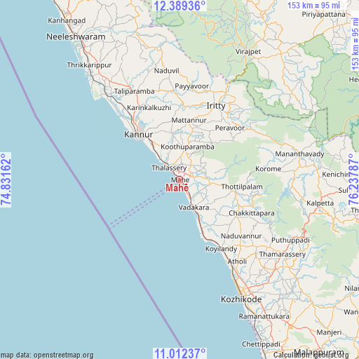
Mahē GPS coordinates[2]
11° 42' 6.192" North, 75° 32' 5.064" East
| Map corner | latitude | longitude |
|---|---|---|
| Upper-left | 12.38936°, | 74.83162° |
| Center: | 11.70172°, | 75.53474° |
| Lower-right: | 11.01237°, | 76.23787° |
| Map W x H: | 153.1×153.1 km | = 95.1×95.1mi |
| max Lat: | 34.9274° ⇑90.6% North |
| Mahē: | 11.70172° |
| min Lat: | ⇓9.4% South 8.09008° |
| min Long | Mahē | max Long |
| 68.82655° | 75.53474° | 96.81° |
| W 21.7%⇐ | ⇒78.3% E |
Elevation
Elevation of Mahē is 22 m = 72 ft, and this is 273.6 m = 898 ft below average elevation for this country.
| Max E: |
3681 m = 12077 ft | 88.1% |
| Avg. | 295.6 m = 970 ft | |
| Mahē | 22 m = 72 ft | |
Min E: |
1 m = 3 ft | 11.9% |
See also: India elevation on elevation.city.
Geographical zone
Mahē is located in North Torrid zone (between Equator and Tropic of Cancer). Distance of Equator is 1301.1 km =808.5 mi to South.| Distance of | km | miles | from Mahē |
|---|---|---|---|
| North Pole | 8706 | 5409.7 | to North |
| Arctic Circle | 6100.1 | 3790.4 | to North |
| Tropic Cancer | 1304.8 | 810.8 | to North |
| Equator | 1301.1 | 808.5 | to South |


Nearby cities:
15 places around Mahē: (largest is in red/bold)
• Azhikkal
31.3 km =19.4 mi,  319°
319°
• Badagara
12.6 km =7.8 mi,  156°
156°
• Dharmadam
11.2 km =7 mi, 317°
• Iringal
18.2 km =11.3 mi,  150°
150°
• Kannavam
21.1 km =13.1 mi,  41°
41°
• Kannur
26.7 km =16.6 mi,  313°
313°
• Mattanur
25.7 km =16 mi,  8°
8°
• Muluppilagadu
14 km =8.7 mi, 319°
• Naduvannūr
35.4 km =22 mi,  132°
132°
• Nādāpuram
13.2 km =8.2 mi,  98°
98°
• Payyannūr
56.6 km =35.2 mi, 320°
• Perya
37.7 km =23.4 mi,  67°
67°
• Pāppinisshēri
35.4 km =22 mi, 323°
• Talipparamba
42.3 km =26.3 mi,  333°
333°
• Tellicherry
6.9 km =4.3 mi, 318°
Sources, notices
• [Note1] Compared only with cities in India existing in our database
• [Src1] Map data: © OpenStreetMap contributors (CC-BY-SA)
• [Src2] Other city data from geonames.org with taken over terms of usage.
• [Src3] Geographical zone / Annual Mean Temperature by Robert A. Rohde @ Wikipedia
