Badagara geodata
Badagara (Kerala) is a populated place; located in India in Asia/Kolkata (GMT+5.5) time zone. With population of 76,493 people, there are 574 cities with bigger population in this country. Compared to other cities in India, 90.9% of cities are located further ↑North; 77.7% of cities are located further →East and 94.3% of cities have higher elevation than Badagara. Note1


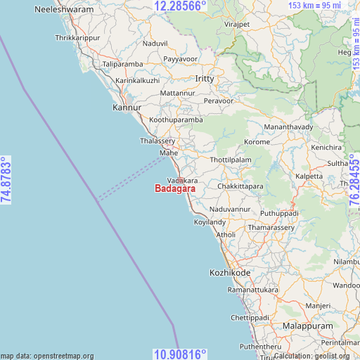
Badagara GPS coordinates[2]
11° 35' 51.936" North, 75° 34' 53.112" East
| Map corner | latitude | longitude |
|---|---|---|
| Upper-left | 12.28566°, | 74.8783° |
| Center: | 11.59776°, | 75.58142° |
| Lower-right: | 10.90816°, | 76.28455° |
| Map W x H: | 153.2×153.2 km | = 95.2×95.2mi |
| max Lat: | 34.9274° ⇑90.9% North |
| Badagara: | 11.59776° |
| min Lat: | ⇓9.1% South 8.09008° |
| min Long | Badagara | max Long |
| 68.82655° | 75.58142° | 96.81° |
| W 22.3%⇐ | ⇒77.7% E |
Elevation
Elevation of Badagara is 12 m = 39 ft, and this is 283.6 m = 930 ft below average elevation for this country.
| Max E: |
3681 m = 12077 ft | 94.3% |
| Avg. | 295.6 m = 970 ft | |
| Badagara | 12 m = 39 ft | |
Min E: |
1 m = 3 ft | 5.7% |
See also: Badagara elevation on elevation.city.
Geographical zone
Badagara is located in North Torrid zone (between Equator and Tropic of Cancer). Distance of Equator is 1289.6 km =801.3 mi to South.| Distance of | km | miles | from Badagara |
|---|---|---|---|
| North Pole | 8717.5 | 5416.8 | to North |
| Arctic Circle | 6111.6 | 3797.6 | to North |
| Tropic Cancer | 1316.4 | 818 | to North |
| Equator | 1289.6 | 801.3 | to South |


Nearby cities:
15 places around Badagara: (largest is in red/bold)
• Azhikkal
43.5 km =27 mi,  324°
324°
• Dharmadam
23.5 km =14.6 mi,  327°
327°
• Iringal
5.7 km =3.5 mi,  138°
138°
• Kannavam
28.8 km =17.9 mi,  17°
17°
• Kannur
38.6 km =24 mi, 320°
• Kozhikode
44.5 km =27.7 mi,  150°
150°
• Kunnamangalam
45.9 km =28.5 mi, 135°
• Mahē
12.6 km =7.8 mi,  336°
336°
• Mattanur
37 km =23 mi,  358°
358°
• Muluppilagadu
26.4 km =16.4 mi, 327°
• Naduvannūr
24.4 km =15.2 mi,  120°
120°
• Nādāpuram
12.5 km =7.8 mi,  39°
39°
• Perya
39.6 km =24.6 mi,  48°
48°
• Pāppinisshēri
47.8 km =29.7 mi, 326°
• Tellicherry
19.3 km =12 mi, 330°
Sources, notices
• [Note1] Compared only with cities in India existing in our database
• [Src1] Map data: © OpenStreetMap contributors (CC-BY-SA)
• [Src2] Other city data from geonames.org with taken over terms of usage.
• [Src3] Geographical zone / Annual Mean Temperature by Robert A. Rohde @ Wikipedia
