Tiruchengode geodata
Tiruchengode (Tamil Nadu) is a populated place; located in India in Asia/Kolkata (GMT+5.5) time zone. With population of 87,123 people, there are 511 cities with bigger population in this country. Compared to other cities in India, 91.8% of cities are located further ↑North; 52.4% of cities are located further →East and 59.3% of cities have lower elevation than Tiruchengode. Note1


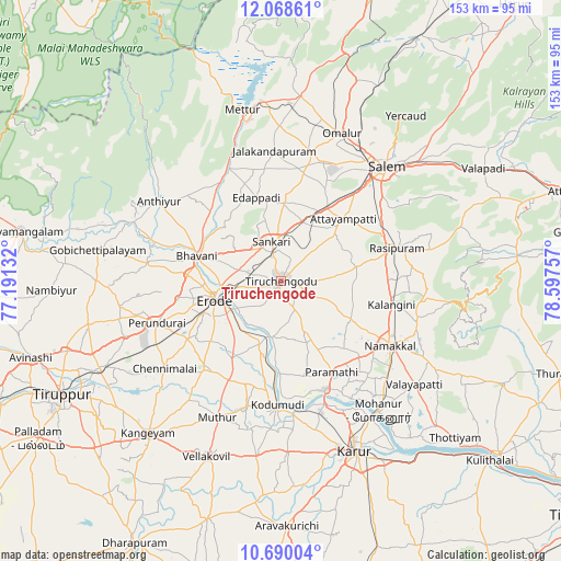
Tiruchengode GPS coordinates[2]
11° 22' 48.576" North, 77° 53' 39.984" East
| Map corner | latitude | longitude |
|---|---|---|
| Upper-left | 12.06861°, | 77.19132° |
| Center: | 11.38016°, | 77.89444° |
| Lower-right: | 10.69004°, | 78.59757° |
| Map W x H: | 153.3×153.3 km | = 95.3×95.3mi |
| max Lat: | 34.9274° ⇑91.8% North |
| Tiruchengode: | 11.38016° |
| min Lat: | ⇓8.2% South 8.09008° |
| min Long | Tiruchengode | max Long |
| 68.82655° | 77.89444° | 96.81° |
| W 47.6%⇐ | ⇒52.4% E |
Elevation
Elevation of Tiruchengode is 246 m = 807 ft, and this is 49.6 m = 163 ft below average elevation for this country.
| Max E: |
3681 m = 12077 ft | 40.7% |
| Avg. | 295.6 m = 970 ft | |
| Tiruchengode | 246 m = 807 ft | |
Min E: |
1 m = 3 ft | 59.3% |
See also: Tiruchengode elevation on elevation.city.
Geographical zone
Tiruchengode is located in North Torrid zone (between Equator and Tropic of Cancer). Distance of Equator is 1265.4 km =786.3 mi to South.| Distance of | km | miles | from Tiruchengode |
|---|---|---|---|
| North Pole | 8741.7 | 5431.8 | to North |
| Arctic Circle | 6135.8 | 3812.6 | to North |
| Tropic Cancer | 1340.6 | 833 | to North |
| Equator | 1265.4 | 786.3 | to South |


Nearby cities:
15 places around Tiruchengode: (largest is in red/bold)
• Ammāpettai
31.4 km =19.5 mi,  328°
328°
• Bhavāni
24.3 km =15.1 mi,  287°
287°
• Erode
18.7 km =11.6 mi,  257°
257°
• Idappadi
23.7 km =14.7 mi,  345°
345°
• Ilampillai
28 km =17.4 mi,  25°
25°
• Kodumudi
33.7 km =20.9 mi,  182°
182°
• Konganāpuram
21.2 km =13.2 mi,  1°
1°
• Mallasamudram
19.5 km =12.1 mi,  49°
49°
• Māllūr
32.5 km =20.2 mi,  55°
55°
• Nāmakkal
34.4 km =21.4 mi,  120°
120°
• Perundurai
35.4 km =22 mi,  250°
250°
• Rasipuram
33 km =20.5 mi,  74°
74°
• Sivagiri
31.1 km =19.3 mi,  201°
201°
• Velur
32.4 km =20.1 mi,  158°
158°
• Āttayyāmpatti
24.3 km =15.1 mi, 45°
Sources, notices
• [Note1] Compared only with cities in India existing in our database
• [Src1] Map data: © OpenStreetMap contributors (CC-BY-SA)
• [Src2] Other city data from geonames.org with taken over terms of usage.
• [Src3] Geographical zone / Annual Mean Temperature by Robert A. Rohde @ Wikipedia
