Ooty geodata
Ooty (Tamil Nadu) is a populated place; located in India in Asia/Kolkata (GMT+5.5) time zone. With population of 98,238 people, there are 449 cities with bigger population in this country. Compared to other cities in India, 91.6% of cities are located further ↑North; 66.4% of cities are located further →East and 99.6% of cities have lower elevation than Ooty. Note1


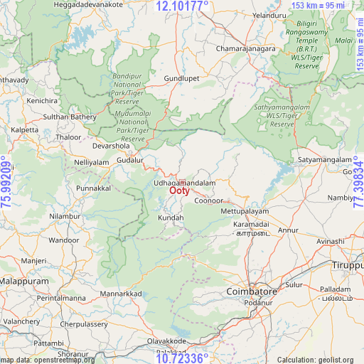
Ooty GPS coordinates[2]
11° 24' 48.24" North, 76° 41' 42.756" East
| Map corner | latitude | longitude |
|---|---|---|
| Upper-left | 12.10177°, | 75.99209° |
| Center: | 11.4134°, | 76.69521° |
| Lower-right: | 10.72336°, | 77.39834° |
| Map W x H: | 153.3×153.3 km | = 95.3×95.3mi |
| max Lat: | 34.9274° ⇑91.6% North |
| Ooty: | 11.4134° |
| min Lat: | ⇓8.4% South 8.09008° |
| min Long | Ooty | max Long |
| 68.82655° | 76.69521° | 96.81° |
| W 33.6%⇐ | ⇒66.4% E |
Elevation
Elevation of Ooty is 2242 m = 7356 ft, and this is 1946.4 m = 6386 ft above average elevation for this country.
| Max E: |
3681 m = 12077 ft | 0.40000000000001% |
| Ooty | 2242 m 7356 ft | |
| Avg. | 295.6 m = 970 ft | |
Min E: |
1 m = 3 ft | 99.6% |
See also: Ooty elevation on elevation.city.
Geographical zone
Ooty is located in North Torrid zone (between Equator and Tropic of Cancer). Distance of Equator is 1269.1 km =788.6 mi to South.| Distance of | km | miles | from Ooty |
|---|---|---|---|
| North Pole | 8738 | 5429.5 | to North |
| Arctic Circle | 6132.1 | 3810.3 | to North |
| Tropic Cancer | 1336.9 | 830.7 | to North |
| Equator | 1269.1 | 788.6 | to South |


Nearby cities:
15 places around Ooty: (largest is in red/bold)
• Annur
48.8 km =30.3 mi,  113°
113°
• Aruvankad
8.8 km =5.5 mi,  129°
129°
• Coimbatore
54.1 km =33.6 mi,  146°
146°
• Gundlupēt
44.1 km =27.4 mi,  359°
359°
• Kotagiri
18 km =11.2 mi,  87°
87°
• Kāramadai
34.7 km =21.6 mi,  123°
123°
• Mannārakkāt
53.2 km =33.1 mi,  208°
208°
• Masinigudi
18.2 km =11.3 mi,  341°
341°
• Mettupalayam
29 km =18 mi, 115°
• Naduvattam
18.1 km =11.2 mi,  294°
294°
• Periyanayakkanpalaiyam
40.3 km =25 mi,  136°
136°
• Perūr
54.2 km =33.7 mi, 154°
• Punjai Puliyampatti
51.9 km =32.2 mi,  97°
97°
• Sirumugai
35.3 km =21.9 mi, 106°
• Wellington
11.1 km =6.9 mi, 118°
Sources, notices
• [Note1] Compared only with cities in India existing in our database
• [Src1] Map data: © OpenStreetMap contributors (CC-BY-SA)
• [Src2] Other city data from geonames.org with taken over terms of usage.
• [Src3] Geographical zone / Annual Mean Temperature by Robert A. Rohde @ Wikipedia
