Kollegāl geodata
Kollegāl (Karnataka) is a populated place; located in India in Asia/Kolkata (GMT+5.5) time zone. With population of 56,497 people, there are 785 cities with bigger population in this country. Compared to other cities in India, 89.4% of cities are located further ↑North; 61.9% of cities are located further →East and 91.1% of cities have lower elevation than Kollegāl. Note1


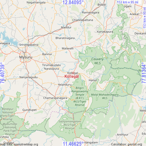
Kollegāl GPS coordinates[2]
12° 9' 16.164" North, 77° 6' 37.836" East
| Map corner | latitude | longitude |
|---|---|---|
| Upper-left | 12.84095°, | 76.40739° |
| Center: | 12.15449°, | 77.11051° |
| Lower-right: | 11.46625°, | 77.81364° |
| Map W x H: | 152.9×152.9 km | = 95×95mi |
| max Lat: | 34.9274° ⇑89.4% North |
| Kollegāl: | 12.15449° |
| min Lat: | ⇓10.6% South 8.09008° |
| min Long | Kollegāl | max Long |
| 68.82655° | 77.11051° | 96.81° |
| W 38.1%⇐ | ⇒61.9% E |
Elevation
Elevation of Kollegāl is 657 m = 2156 ft, and this is 361.4 m = 1186 ft above average elevation for this country.
| Max E: |
3681 m = 12077 ft | 8.9% |
| Kollegāl | 657 m 2156 ft | |
| Avg. | 295.6 m = 970 ft | |
Min E: |
1 m = 3 ft | 91.1% |
See also: Kollegāl elevation on elevation.city.
Geographical zone
Kollegāl is located in North Torrid zone (between Equator and Tropic of Cancer). Distance of this Northern Tropic circle is 1254.5 km =779.5 mi to North.| Distance of | km | miles | from Kollegāl |
|---|---|---|---|
| North Pole | 8655.6 | 5378.3 | to North |
| Arctic Circle | 6049.7 | 3759.1 | to North |
| Tropic Cancer | 1254.5 | 779.5 | to North |
| Equator | 1351.5 | 839.8 | to South |


Nearby cities:
15 places around Kollegāl: (largest is in red/bold)
• Bannūr
33.5 km =20.8 mi,  306°
306°
• Chamrajnagar
31.7 km =19.7 mi,  215°
215°
• Channapatna
56.2 km =34.9 mi,  10°
10°
• Closepet
65.8 km =40.9 mi,  16°
16°
• French Rocks
61.1 km =38 mi, 309°
• Gundlupēt
59.6 km =37 mi,  230°
230°
• Kānkānhalli
55.1 km =34.2 mi,  37°
37°
• Maddūr
48.2 km =30 mi,  351°
351°
• Malavalli
26.3 km =16.3 mi, 348°
• Mandya
47 km =29.2 mi,  330°
330°
• Mysore
53.6 km =33.3 mi,  287°
287°
• Nanjangūd
46.5 km =28.9 mi,  264°
264°
• Shrīrangapattana
55.1 km =34.2 mi,  302°
302°
• Tirumakūdal Narsipur
23.6 km =14.7 mi, 285°
• Yelandūr
14.9 km =9.3 mi, 215°
Sources, notices
• [Note1] Compared only with cities in India existing in our database
• [Src1] Map data: © OpenStreetMap contributors (CC-BY-SA)
• [Src2] Other city data from geonames.org with taken over terms of usage.
• [Src3] Geographical zone / Annual Mean Temperature by Robert A. Rohde @ Wikipedia
