Aruvankad geodata
Aruvankad (Tamil Nadu) is a populated place; located in India in Asia/Kolkata (GMT+5.5) time zone. With population of 5,175 people, there are 3335 cities with bigger population in this country. Compared to other cities in India, 91.8% of cities are located further ↑North; 65.5% of cities are located further →East and 99.3% of cities have lower elevation than Aruvankad. Note1


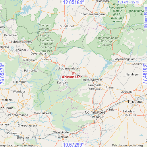
Aruvankad GPS coordinates[2]
11° 21' 47.34" North, 76° 45' 28.44" East
| Map corner | latitude | longitude |
|---|---|---|
| Upper-left | 12.05164°, | 76.05478° |
| Center: | 11.36315°, | 76.7579° |
| Lower-right: | 10.67299°, | 77.46103° |
| Map W x H: | 153.3×153.3 km | = 95.3×95.3mi |
| max Lat: | 34.9274° ⇑91.8% North |
| Aruvankad: | 11.36315° |
| min Lat: | ⇓8.2% South 8.09008° |
| min Long | Aruvankad | max Long |
| 68.82655° | 76.7579° | 96.81° |
| W 34.5%⇐ | ⇒65.5% E |
Elevation
Elevation of Aruvankad is 1920 m = 6299 ft, and this is 1624.4 m = 5329 ft above average elevation for this country.
| Max E: |
3681 m = 12077 ft | 0.7% |
| Aruvankad | 1920 m 6299 ft | |
| Avg. | 295.6 m = 970 ft | |
Min E: |
1 m = 3 ft | 99.3% |
See also: India elevation on elevation.city.
Geographical zone
Aruvankad is located in North Torrid zone (between Equator and Tropic of Cancer). Distance of Equator is 1263.5 km =785.1 mi to South.| Distance of | km | miles | from Aruvankad |
|---|---|---|---|
| North Pole | 8743.6 | 5433 | to North |
| Arctic Circle | 6137.7 | 3813.8 | to North |
| Tropic Cancer | 1342.5 | 834.2 | to North |
| Equator | 1263.5 | 785.1 | to South |


Nearby cities:
15 places around Aruvankad: (largest is in red/bold)
• Annur
40.4 km =25.1 mi,  110°
110°
• Coimbatore
45.8 km =28.5 mi,  150°
150°
• Gundlupēt
50.2 km =31.2 mi,  351°
351°
• Kotagiri
12.9 km =8 mi,  60°
60°
• Kāramadai
25.9 km =16.1 mi,  121°
121°
• Masinigudi
26.1 km =16.2 mi,  330°
330°
• Mettupalayam
20.5 km =12.7 mi, 110°
• Naduvattam
26.8 km =16.7 mi,  299°
299°
• Ooty
8.8 km =5.5 mi,  309°
309°
• Periyanayakkanpalaiyam
31.5 km =19.6 mi,  137°
137°
• Perūr
46.3 km =28.8 mi,  158°
158°
• Punjai Puliyampatti
44.6 km =27.7 mi,  91°
91°
• Singānallūr
50.4 km =31.3 mi, 143°
• Sirumugai
27.4 km =17 mi,  99°
99°
• Wellington
2.9 km =1.8 mi,  84°
84°
Sources, notices
• [Note1] Compared only with cities in India existing in our database
• [Src1] Map data: © OpenStreetMap contributors (CC-BY-SA)
• [Src2] Other city data from geonames.org with taken over terms of usage.
• [Src3] Geographical zone / Annual Mean Temperature by Robert A. Rohde @ Wikipedia
