Kotagiri geodata
Kotagiri (Tamil Nadu) is a populated place; located in India in Asia/Kolkata (GMT+5.5) time zone. With population of 28,848 people, there are 1502 cities with bigger population in this country. Compared to other cities in India, 91.6% of cities are located further ↑North; 64.7% of cities are located further →East and 99.2% of cities have lower elevation than Kotagiri. Note1


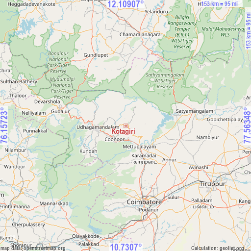
Kotagiri GPS coordinates[2]
11° 25' 14.592" North, 76° 51' 37.26" East
| Map corner | latitude | longitude |
|---|---|---|
| Upper-left | 12.10907°, | 76.15723° |
| Center: | 11.42072°, | 76.86035° |
| Lower-right: | 10.7307°, | 77.56348° |
| Map W x H: | 153.3×153.3 km | = 95.3×95.3mi |
| max Lat: | 34.9274° ⇑91.6% North |
| Kotagiri: | 11.42072° |
| min Lat: | ⇓8.4% South 8.09008° |
| min Long | Kotagiri | max Long |
| 68.82655° | 76.86035° | 96.81° |
| W 35.3%⇐ | ⇒64.7% E |
Elevation
Elevation of Kotagiri is 1902 m = 6240 ft, and this is 1606.4 m = 5270 ft above average elevation for this country.
| Max E: |
3681 m = 12077 ft | 0.8% |
| Kotagiri | 1902 m 6240 ft | |
| Avg. | 295.6 m = 970 ft | |
Min E: |
1 m = 3 ft | 99.2% |
See also: India elevation on elevation.city.
Geographical zone
Kotagiri is located in North Torrid zone (between Equator and Tropic of Cancer). Distance of Equator is 1269.9 km =789.1 mi to South.| Distance of | km | miles | from Kotagiri |
|---|---|---|---|
| North Pole | 8737.2 | 5429 | to North |
| Arctic Circle | 6131.3 | 3809.8 | to North |
| Tropic Cancer | 1336.1 | 830.2 | to North |
| Equator | 1269.9 | 789.1 | to South |


Nearby cities:
15 places around Kotagiri: (largest is in red/bold)
• Annur
33.7 km =20.9 mi,  127°
127°
• Aruvankad
12.9 km =8 mi,  240°
240°
• Coimbatore
47.6 km =29.6 mi,  165°
165°
• Gundlupēt
47.1 km =29.3 mi,  336°
336°
• Irugūr
49.9 km =31 mi,  153°
153°
• Kāramadai
22.8 km =14.2 mi, 151°
• Masinigudi
29 km =18 mi,  304°
304°
• Mettupalayam
15.7 km =9.8 mi, 148°
• Naduvattam
35.2 km =21.9 mi,  280°
280°
• Ooty
18 km =11.2 mi,  267°
267°
• Periyanayakkanpalaiyam
31.4 km =19.5 mi,  161°
161°
• Punjai Puliyampatti
34.3 km =21.3 mi,  102°
102°
• Sathyamangalam
42.2 km =26.2 mi,  77°
77°
• Sirumugai
19.3 km =12 mi,  124°
124°
• Wellington
10.3 km =6.4 mi,  233°
233°
Sources, notices
• [Note1] Compared only with cities in India existing in our database
• [Src1] Map data: © OpenStreetMap contributors (CC-BY-SA)
• [Src2] Other city data from geonames.org with taken over terms of usage.
• [Src3] Geographical zone / Annual Mean Temperature by Robert A. Rohde @ Wikipedia
