Bhawānipatna geodata
Bhawānipatna (Odisha) is a populated place; located in India in Asia/Kolkata (GMT+5.5) time zone. With population of 64,468 people, there are 682 cities with bigger population in this country. Compared to other cities in India, 65.6% of cities are located further ↑North; 79.8% of cities are located further ←West and 61.2% of cities have lower elevation than Bhawānipatna. Note1


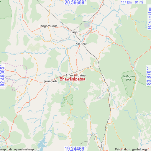
Bhawānipatna GPS coordinates[2]
19° 54' 25.812" North, 83° 10' 1.092" East
| Map corner | latitude | longitude |
|---|---|---|
| Upper-left | 20.56689°, | 82.46385° |
| Center: | 19.90717°, | 83.16697° |
| Lower-right: | 19.24469°, | 83.8701° |
| Map W x H: | 147×147 km | = 91.3×91.3mi |
| max Lat: | 34.9274° ⇑65.6% North |
| Bhawānipatna: | 19.90717° |
| min Lat: | ⇓34.4% South 8.09008° |
| min Long | Bhawānipatna | max Long |
| 68.82655° | 83.16697° | 96.81° |
| W 79.8%⇐ | ⇒20.2% E |
Elevation
Elevation of Bhawānipatna is 259 m = 850 ft, and this is 36.6 m = 120 ft below average elevation for this country.
| Max E: |
3681 m = 12077 ft | 38.8% |
| Avg. | 295.6 m = 970 ft | |
| Bhawānipatna | 259 m = 850 ft | |
Min E: |
1 m = 3 ft | 61.2% |
See also: Bhawānipatna elevation on elevation.city.
Geographical zone
Bhawānipatna is located in North Torrid zone (between Equator and Tropic of Cancer). Distance of this Northern Tropic circle is 392.4 km =243.8 mi to North.| Distance of | km | miles | from Bhawānipatna |
|---|---|---|---|
| North Pole | 7793.6 | 4842.7 | to North |
| Arctic Circle | 5187.7 | 3223.5 | to North |
| Tropic Cancer | 392.4 | 243.8 | to North |
| Equator | 2213.5 | 1375.4 | to South |


Nearby cities:
15 places around Bhawānipatna: (largest is in red/bold)
• Balāngīr
94.8 km =58.9 mi,  20°
20°
• Gudāri
89.5 km =55.6 mi,  134°
134°
• Gunupur
113.9 km =70.8 mi,  143°
143°
• Jūnāgarh
24.9 km =15.5 mi,  257°
257°
• Kantābānji
67.4 km =41.9 mi,  337°
337°
• Kesinga
31.7 km =19.7 mi,  9°
9°
• Kharhiāl
60 km =37.3 mi,  314°
314°
• Kotapārh
122.5 km =76.1 mi,  226°
226°
• Nowrangapur
99.3 km =61.7 mi,  220°
220°
• Padampur
121.9 km =75.7 mi,  354°
354°
• Patnāgarh
89.2 km =55.4 mi,  357°
357°
• Tarabha
105.9 km =65.8 mi,  29°
29°
• Titlāgarh
42.6 km =26.5 mi, 357°
• Udayagiri
127.8 km =79.4 mi,  79°
79°
• Umarkot
104 km =64.6 mi, 255°
Sources, notices
• [Note1] Compared only with cities in India existing in our database
• [Src1] Map data: © OpenStreetMap contributors (CC-BY-SA)
• [Src2] Other city data from geonames.org with taken over terms of usage.
• [Src3] Geographical zone / Annual Mean Temperature by Robert A. Rohde @ Wikipedia
