Raurkela geodata
Raurkela (Odisha) is a populated place; located in India in Asia/Kolkata (GMT+5.5) time zone. With population of 536,450 people, there are 79 cities with bigger population in this country. Compared to other cities in India, 55% of cities are located further ↑North; 83.9% of cities are located further ←West and 51.3% of cities have higher elevation than Raurkela. Note1


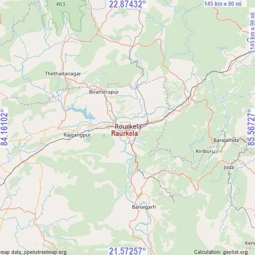
Raurkela GPS coordinates[2]
22° 13' 29.856" North, 84° 51' 50.904" East
| Map corner | latitude | longitude |
|---|---|---|
| Upper-left | 22.87432°, | 84.16102° |
| Center: | 22.22496°, | 84.86414° |
| Lower-right: | 21.57257°, | 85.56727° |
| Map W x H: | 144.7×144.7 km | = 89.9×89.9mi |
| max Lat: | 34.9274° ⇑55% North |
| Raurkela: | 22.22496° |
| min Lat: | ⇓45% South 8.09008° |
| min Long | Raurkela | max Long |
| 68.82655° | 84.86414° | 96.81° |
| W 83.9%⇐ | ⇒16.1% E |
Elevation
Elevation of Raurkela is 195 m = 640 ft, and this is 100.6 m = 330 ft below average elevation for this country.
| Max E: |
3681 m = 12077 ft | 51.3% |
| Avg. | 295.6 m = 970 ft | |
| Raurkela | 195 m = 640 ft | |
Min E: |
1 m = 3 ft | 48.7% |
See also: Raurkela elevation on elevation.city.
Geographical zone
Raurkela is located in North Torrid zone (between Equator and Tropic of Cancer). Distance of this Northern Tropic circle is 134.7 km =83.7 mi to North.| Distance of | km | miles | from Raurkela |
|---|---|---|---|
| North Pole | 7535.9 | 4682.6 | to North |
| Arctic Circle | 4930 | 3063.4 | to North |
| Tropic Cancer | 134.7 | 83.7 | to North |
| Equator | 2471.2 | 1535.5 | to South |


Nearby cities:
15 places around Raurkela: (largest is in red/bold)
• Bada Barabīl
55.3 km =34.4 mi,  103°
103°
• Barbil
54.6 km =33.9 mi, 104°
• Birmitrapur
21.9 km =13.6 mi,  332°
332°
• Bolānīkhodān
50.2 km =31.2 mi, 104°
• Bānposh
6.1 km =3.8 mi,  295°
295°
• Chiria
43.4 km =27 mi,  77°
77°
• Chāmpua
84.3 km =52.4 mi, 102°
• Deogarh
77.5 km =48.2 mi,  190°
190°
• Gua
53.9 km =33.5 mi,  91°
91°
• Jagannāthpur
79.8 km =49.6 mi, 90°
• Kiri Buru
52.5 km =32.6 mi,  107°
107°
• Kuchinda
75.4 km =46.9 mi,  224°
224°
• Manoharpur
37.6 km =23.4 mi,  63°
63°
• Noāmundi
66.3 km =41.2 mi, 96°
• Simdega
57.2 km =35.5 mi,  319°
319°
Sources, notices
• [Note1] Compared only with cities in India existing in our database
• [Src1] Map data: © OpenStreetMap contributors (CC-BY-SA)
• [Src2] Other city data from geonames.org with taken over terms of usage.
• [Src3] Geographical zone / Annual Mean Temperature by Robert A. Rohde @ Wikipedia
