Deoria geodata
Deoria (Uttar Pradesh) is a populated place; located in India in Asia/Kolkata (GMT+5.5) time zone. With population of 129,570 people, there are 338 cities with bigger population in this country. Compared to other cities in India, 74.8% of cities are located further ↓South; 81.4% of cities are located further ←West and 72.5% of cities have higher elevation than Deoria. Note1


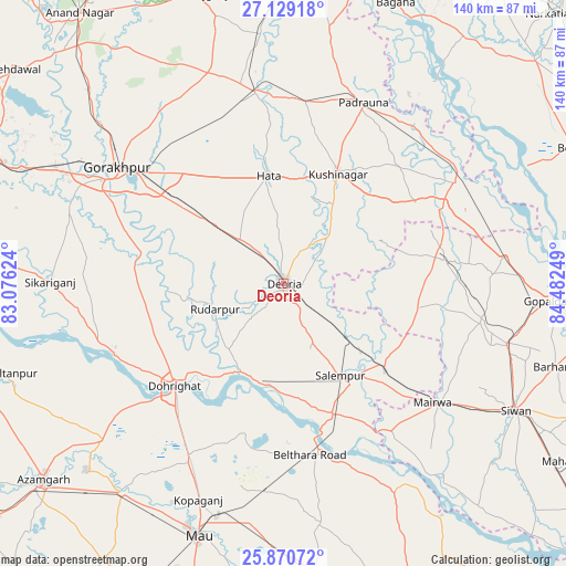
Deoria GPS coordinates[2]
26° 30' 6.012" North, 83° 46' 45.696" East
| Map corner | latitude | longitude |
|---|---|---|
| Upper-left | 27.12918°, | 83.07624° |
| Center: | 26.50167°, | 83.77936° |
| Lower-right: | 25.87072°, | 84.48249° |
| Map W x H: | 139.9×139.9 km | = 86.9×86.9mi |
| max Lat: | 34.9274° ⇑25.2% North |
| Deoria: | 26.50167° |
| min Lat: | ⇓74.8% South 8.09008° |
| min Long | Deoria | max Long |
| 68.82655° | 83.77936° | 96.81° |
| W 81.4%⇐ | ⇒18.6% E |
Elevation
Elevation of Deoria is 82 m = 269 ft, and this is 213.6 m = 701 ft below average elevation for this country.
| Max E: |
3681 m = 12077 ft | 72.5% |
| Avg. | 295.6 m = 970 ft | |
| Deoria | 82 m = 269 ft | |
Min E: |
1 m = 3 ft | 27.5% |
See also: Deoria elevation on elevation.city.
Geographical zone
Deoria is located in North temperate zone (between Tropic of Cancer and the Arctic Circle). Distance of this Northern Tropic circle is 340.8 km =211.8 mi to South.| Distance of | km | miles | from Deoria |
|---|---|---|---|
| North Pole | 7060.4 | 4387.1 | to North |
| Arctic Circle | 4454.5 | 2767.9 | to North |
| Tropic Cancer | 340.8 | 211.8 | to South |
| Equator | 2946.7 | 1831 | to South |


Nearby cities:
15 places around Deoria: (largest is in red/bold)
• Bilthra
43.1 km =26.8 mi,  164°
164°
• Bānsgāon
43.5 km =27 mi,  277°
277°
• Captainganj
47.7 km =29.6 mi,  352°
352°
• Chillupār
36.5 km =22.7 mi,  228°
228°
• Dohrighāt
37.1 km =23.1 mi, 226°
• Ghosī
50.1 km =31.1 mi,  208°
208°
• Gola Bāzār
45.9 km =28.5 mi,  247°
247°
• Gorakhpur
50.3 km =31.3 mi,  305°
305°
• Hātā
26.8 km =16.7 mi, 352°
• Lar
38.1 km =23.7 mi,  150°
150°
• Mairwa
48.6 km =30.2 mi,  128°
128°
• Padrauna
49 km =30.4 mi,  24°
24°
• Pipraich
44.1 km =27.4 mi,  325°
325°
• Rāmkola
44.9 km =27.9 mi,  7°
7°
• Rūdarpur
17.7 km =11 mi, 249°
Sources, notices
• [Note1] Compared only with cities in India existing in our database
• [Src1] Map data: © OpenStreetMap contributors (CC-BY-SA)
• [Src2] Other city data from geonames.org with taken over terms of usage.
• [Src3] Geographical zone / Annual Mean Temperature by Robert A. Rohde @ Wikipedia
