Rūdarpur geodata
Rūdarpur (Uttar Pradesh) is a populated place; located in India in Asia/Kolkata (GMT+5.5) time zone. With population of 30,873 people, there are 1406 cities with bigger population in this country. Compared to other cities in India, 74.1% of cities are located further ↓South; 81.1% of cities are located further ←West and 73% of cities have higher elevation than Rūdarpur. Note1


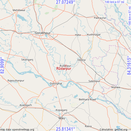
Rūdarpur GPS coordinates[2]
26° 26' 40.812" North, 83° 36' 46.872" East
| Map corner | latitude | longitude |
|---|---|---|
| Upper-left | 27.07249°, | 82.9099° |
| Center: | 26.44467°, | 83.61302° |
| Lower-right: | 25.81341°, | 84.31615° |
| Map W x H: | 140×140 km | = 87×87mi |
| max Lat: | 34.9274° ⇑25.9% North |
| Rūdarpur: | 26.44467° |
| min Lat: | ⇓74.1% South 8.09008° |
| min Long | Rūdarpur | max Long |
| 68.82655° | 83.61302° | 96.81° |
| W 81.1%⇐ | ⇒18.9% E |
Elevation
Elevation of Rūdarpur is 79 m = 259 ft, and this is 216.6 m = 711 ft below average elevation for this country.
| Max E: |
3681 m = 12077 ft | 73% |
| Avg. | 295.6 m = 970 ft | |
| Rūdarpur | 79 m = 259 ft | |
Min E: |
1 m = 3 ft | 27% |
See also: India elevation on elevation.city.
Geographical zone
Rūdarpur is located in North temperate zone (between Tropic of Cancer and the Arctic Circle). Distance of this Northern Tropic circle is 334.5 km =207.8 mi to South.| Distance of | km | miles | from Rūdarpur |
|---|---|---|---|
| North Pole | 7066.7 | 4391 | to North |
| Arctic Circle | 4460.8 | 2771.8 | to North |
| Tropic Cancer | 334.5 | 207.8 | to South |
| Equator | 2940.4 | 1827.1 | to South |


Nearby cities:
15 places around Rūdarpur: (largest is in red/bold)
• Bilariāganj
47.4 km =29.5 mi,  234°
234°
• Bilthra
44.9 km =27.9 mi,  141°
141°
• Bānsgāon
29.1 km =18.1 mi,  293°
293°
• Chillupār
21 km =13 mi,  210°
210°
• Deoria
17.7 km =11 mi,  69°
69°
• Dohrighāt
21.8 km =13.5 mi, 208°
• Ghosī
38.4 km =23.9 mi,  191°
191°
• Gola Bāzār
28.2 km =17.5 mi,  246°
246°
• Gorakhpur
43.2 km =26.8 mi,  325°
325°
• Hātā
35.5 km =22.1 mi,  21°
21°
• Jainpur
42.6 km =26.5 mi,  220°
220°
• Kopāganj
47.5 km =29.5 mi, 185°
• Lar
44.4 km =27.6 mi,  127°
127°
• Mubārakpur
51 km =31.7 mi, 219°
• Pipraich
43.4 km =27 mi,  348°
348°
Sources, notices
• [Note1] Compared only with cities in India existing in our database
• [Src1] Map data: © OpenStreetMap contributors (CC-BY-SA)
• [Src2] Other city data from geonames.org with taken over terms of usage.
• [Src3] Geographical zone / Annual Mean Temperature by Robert A. Rohde @ Wikipedia
