Gokak geodata
Gokak (Karnataka) is a populated place; located in India in Asia/Kolkata (GMT+5.5) time zone. With population of 73,478 people, there are 599 cities with bigger population in this country. Compared to other cities in India, 77.5% of cities are located further ↑North; 84.2% of cities are located further →East and 85.4% of cities have lower elevation than Gokak. Note1


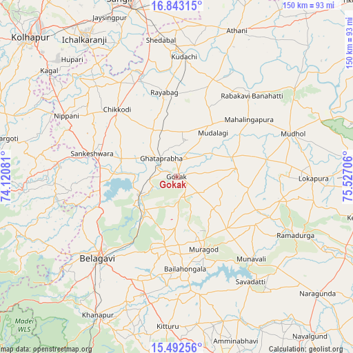
Gokak GPS coordinates[2]
16° 10' 8.436" North, 74° 49' 26.148" East
| Map corner | latitude | longitude |
|---|---|---|
| Upper-left | 16.84315°, | 74.12081° |
| Center: | 16.16901°, | 74.82393° |
| Lower-right: | 15.49256°, | 75.52706° |
| Map W x H: | 150.2×150.2 km | = 93.3×93.3mi |
| max Lat: | 34.9274° ⇑77.5% North |
| Gokak: | 16.16901° |
| min Lat: | ⇓22.5% South 8.09008° |
| min Long | Gokak | max Long |
| 68.82655° | 74.82393° | 96.81° |
| W 15.8%⇐ | ⇒84.2% E |
Elevation
Elevation of Gokak is 555 m = 1821 ft, and this is 259.4 m = 851 ft above average elevation for this country.
| Max E: |
3681 m = 12077 ft | 14.6% |
| Gokak | 555 m 1821 ft | |
| Avg. | 295.6 m = 970 ft | |
Min E: |
1 m = 3 ft | 85.4% |
See also: Gokak elevation on elevation.city.
Geographical zone
Gokak is located in North Torrid zone (between Equator and Tropic of Cancer). Distance of this Northern Tropic circle is 808.1 km =502.1 mi to North.| Distance of | km | miles | from Gokak |
|---|---|---|---|
| North Pole | 8209.2 | 5101 | to North |
| Arctic Circle | 5603.3 | 3481.7 | to North |
| Tropic Cancer | 808.1 | 502.1 | to North |
| Equator | 1797.8 | 1117.1 | to South |


Nearby cities:
15 places around Gokak: (largest is in red/bold)
• Bail-Hongal
39.7 km =24.7 mi,  174°
174°
• Belgaum
49.1 km =30.5 mi,  224°
224°
• Chikodi
38.5 km =23.9 mi,  318°
318°
• Gadhinglaj
50.9 km =31.6 mi,  276°
276°
• Hukeri
24.6 km =15.3 mi,  286°
286°
• Konnūr
8.8 km =5.5 mi, 294°
• Kudachi
51.1 km =31.8 mi,  3°
3°
• Mahālingpur
39 km =24.2 mi,  51°
51°
• Mudhol
52.3 km =32.5 mi,  69°
69°
• Rabkavi
45.8 km =28.5 mi,  41°
41°
• Rāybāg
36.3 km =22.6 mi,  351°
351°
• Sadalgi
53.4 km =33.2 mi, 324°
• Sankeshwar
37.8 km =23.5 mi, 284°
• Shiraguppi
51.5 km =32 mi, 346°
• Terdāl
43.2 km =26.8 mi,  33°
33°
Sources, notices
• [Note1] Compared only with cities in India existing in our database
• [Src1] Map data: © OpenStreetMap contributors (CC-BY-SA)
• [Src2] Other city data from geonames.org with taken over terms of usage.
• [Src3] Geographical zone / Annual Mean Temperature by Robert A. Rohde @ Wikipedia
