Mudhol geodata
Mudhol (Karnataka) is a populated place; located in India in Asia/Kolkata (GMT+5.5) time zone. With population of 47,427 people, there are 931 cities with bigger population in this country. Compared to other cities in India, 77.1% of cities are located further ↑North; 80.3% of cities are located further →East and 84.7% of cities have lower elevation than Mudhol. Note1


Mudhol GPS coordinates[2]
16° 20' 0.744" North, 75° 16' 58.98" East
| Map corner | latitude | longitude |
|---|---|---|
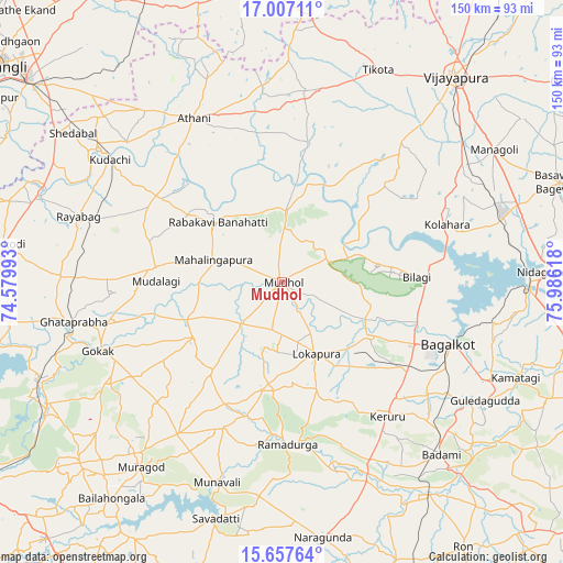
| Upper-left | 17.00711°, | 74.57993° |
| Center: | 16.33354°, | 75.28305° |
| Lower-right: | 15.65764°, | 75.98618° |
| Map W x H: | 150×150 km | = 93.2×93.2mi |
| max Lat: | 34.9274° ⇑77.1% North |
| Mudhol: | 16.33354° |
| min Lat: | ⇓22.9% South 8.09008° |
| min Long | Mudhol | max Long |
| 68.82655° | 75.28305° | 96.81° |
| W 19.7%⇐ | ⇒80.3% E |
Elevation
Elevation of Mudhol is 547 m = 1795 ft, and this is 251.4 m = 825 ft above average elevation for this country.
| Max E: |
3681 m = 12077 ft | 15.3% |
| Mudhol | 547 m 1795 ft | |
| Avg. | 295.6 m = 970 ft | |
Min E: |
1 m = 3 ft | 84.7% |
See also: Mudhol elevation on elevation.city.
Geographical zone
Mudhol is located in North Torrid zone (between Equator and Tropic of Cancer). Distance of this Northern Tropic circle is 789.8 km =490.8 mi to North.| Distance of | km | miles | from Mudhol |
|---|---|---|---|
| North Pole | 8190.9 | 5089.6 | to North |
| Arctic Circle | 5585.1 | 3470.4 | to North |
| Tropic Cancer | 789.8 | 490.8 | to North |
| Equator | 1816.1 | 1128.5 | to South |


Nearby cities:
15 places around Mudhol: (largest is in red/bold)
• Athni
49.5 km =30.8 mi,  331°
331°
• Bagalkot
47 km =29.2 mi,  110°
110°
• Bilgi
35.8 km =22.2 mi,  87°
87°
• Bādāmi
62.7 km =39 mi,  137°
137°
• Gokak
52.3 km =32.5 mi,  249°
249°
• Guledagudda
62.6 km =38.9 mi,  120°
120°
• Jamkhandi
19 km =11.8 mi,  2°
2°
• Kerūr
45.3 km =28.1 mi, 141°
• Konnūr
58.9 km =36.6 mi,  255°
255°
• Kudachi
56.2 km =34.9 mi,  305°
305°
• Mahālingpur
19.6 km =12.2 mi,  288°
288°
• Rabkavi
24.3 km =15.1 mi, 310°
• Rāybāg
57.1 km =35.5 mi, 287°
• Saundatti
65.5 km =40.7 mi,  195°
195°
• Terdāl
30.9 km =19.2 mi, 305°
Sources, notices
• [Note1] Compared only with cities in India existing in our database
• [Src1] Map data: © OpenStreetMap contributors (CC-BY-SA)
• [Src2] Other city data from geonames.org with taken over terms of usage.
• [Src3] Geographical zone / Annual Mean Temperature by Robert A. Rohde @ Wikipedia
