Rāmpur geodata
Rāmpur (Uttar Pradesh) is a populated place; located in India in Asia/Kolkata (GMT+5.5) time zone. With population of 26,257 people, there are 1624 cities with bigger population in this country. Compared to other cities in India, 92.2% of cities are located further ↓South; 57.8% of cities are located further →East and 62.8% of cities have lower elevation than Rāmpur. Note1


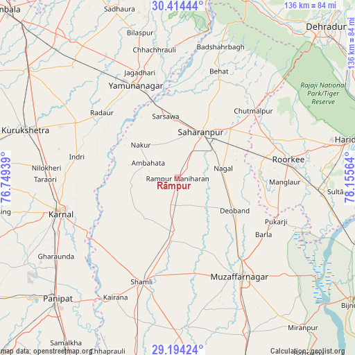
Rāmpur GPS coordinates[2]
29° 48' 22.32" North, 77° 27' 9.036" East
| Map corner | latitude | longitude |
|---|---|---|
| Upper-left | 30.41444°, | 76.74939° |
| Center: | 29.8062°, | 77.45251° |
| Lower-right: | 29.19424°, | 78.15564° |
| Map W x H: | 135.7×135.7 km | = 84.3×84.3mi |
| max Lat: | 34.9274° ⇑7.8% North |
| Rāmpur: | 29.8062° |
| min Lat: | ⇓92.2% South 8.09008° |
| min Long | Rāmpur | max Long |
| 68.82655° | 77.45251° | 96.81° |
| W 42.2%⇐ | ⇒57.8% E |
Elevation
Elevation of Rāmpur is 270 m = 886 ft, and this is 25.6 m = 84 ft below average elevation for this country.
| Max E: |
3681 m = 12077 ft | 37.2% |
| Avg. | 295.6 m = 970 ft | |
| Rāmpur | 270 m = 886 ft | |
Min E: |
1 m = 3 ft | 62.8% |
See also: India elevation on elevation.city.
Geographical zone
Rāmpur is located in North temperate zone (between Tropic of Cancer and the Arctic Circle). Distance of this Northern Tropic circle is 708.2 km =440.1 mi to South.| Distance of | km | miles | from Rāmpur |
|---|---|---|---|
| North Pole | 6692.9 | 4158.8 | to North |
| Arctic Circle | 4087 | 2539.5 | to North |
| Tropic Cancer | 708.2 | 440.1 | to South |
| Equator | 3314.1 | 2059.3 | to South |


Nearby cities:
15 places around Rāmpur: (largest is in red/bold)
• Ambahta
12.6 km =7.8 mi,  296°
296°
• Charthāwal
31.9 km =19.8 mi,  154°
154°
• Chhutmalpur
38.4 km =23.9 mi,  49°
49°
• Deoband
25.2 km =15.7 mi,  119°
119°
• Gangoh
18.5 km =11.5 mi,  260°
260°
• Garhi Pūkhta
31.7 km =19.7 mi,  205°
205°
• Jalālābad
20.9 km =13 mi,  183°
183°
• Jhinjhāna
38.6 km =24 mi, 214°
• Nakūr
19.1 km =11.9 mi,  311°
311°
• Nanauta
11 km =6.8 mi,  198°
198°
• Radaur
38 km =23.6 mi, 310°
• Sahāranpur
20.1 km =12.5 mi,  26°
26°
• Thāna Bhawan
24.7 km =15.3 mi,  187°
187°
• Titron
19.7 km =12.2 mi,  218°
218°
• Ūn
31.1 km =19.3 mi, 217°
Sources, notices
• [Note1] Compared only with cities in India existing in our database
• [Src1] Map data: © OpenStreetMap contributors (CC-BY-SA)
• [Src2] Other city data from geonames.org with taken over terms of usage.
• [Src3] Geographical zone / Annual Mean Temperature by Robert A. Rohde @ Wikipedia
