Nanauta geodata
Nanauta (Uttar Pradesh) is a populated place; located in India in Asia/Kolkata (GMT+5.5) time zone. With population of 18,738 people, there are 2152 cities with bigger population in this country. Compared to other cities in India, 91.9% of cities are located further ↓South; 58.2% of cities are located further →East and 62.4% of cities have lower elevation than Nanauta. Note1


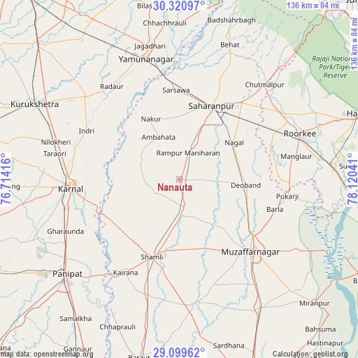
Nanauta GPS coordinates[2]
29° 42' 43.74" North, 77° 25' 2.208" East
| Map corner | latitude | longitude |
|---|---|---|
| Upper-left | 30.32097°, | 76.71416° |
| Center: | 29.71215°, | 77.41728° |
| Lower-right: | 29.09962°, | 78.12041° |
| Map W x H: | 135.8×135.8 km | = 84.4×84.4mi |
| max Lat: | 34.9274° ⇑8.1% North |
| Nanauta: | 29.71215° |
| min Lat: | ⇓91.9% South 8.09008° |
| min Long | Nanauta | max Long |
| 68.82655° | 77.41728° | 96.81° |
| W 41.8%⇐ | ⇒58.2% E |
Elevation
Elevation of Nanauta is 267 m = 876 ft, and this is 28.6 m = 94 ft below average elevation for this country.
| Max E: |
3681 m = 12077 ft | 37.6% |
| Avg. | 295.6 m = 970 ft | |
| Nanauta | 267 m = 876 ft | |
Min E: |
1 m = 3 ft | 62.4% |
See also: India elevation on elevation.city.
Geographical zone
Nanauta is located in North temperate zone (between Tropic of Cancer and the Arctic Circle). Distance of this Northern Tropic circle is 697.8 km =433.6 mi to South.| Distance of | km | miles | from Nanauta |
|---|---|---|---|
| North Pole | 6703.4 | 4165.3 | to North |
| Arctic Circle | 4097.5 | 2546.1 | to North |
| Tropic Cancer | 697.8 | 433.6 | to South |
| Equator | 3303.7 | 2052.8 | to South |


Nearby cities:
15 places around Nanauta: (largest is in red/bold)
• Ambahta
17.9 km =11.1 mi,  333°
333°
• Banat
28.3 km =17.6 mi,  192°
192°
• Charthāwal
25.1 km =15.6 mi,  137°
137°
• Deoband
25.4 km =15.8 mi,  94°
94°
• Gangoh
16.7 km =10.4 mi,  296°
296°
• Garhi Pūkhta
20.9 km =13 mi,  210°
210°
• Jalālābad
10.6 km =6.6 mi,  168°
168°
• Jhinjhāna
28.2 km =17.5 mi,  221°
221°
• Nakūr
25.5 km =15.8 mi, 334°
• Rāmpur
11 km =6.8 mi,  18°
18°
• Sahāranpur
31 km =19.3 mi, 23°
• Shāmli
31 km =19.3 mi,  199°
199°
• Thāna Bhawan
14 km =8.7 mi,  179°
179°
• Titron
10.3 km =6.4 mi,  241°
241°
• Ūn
21.1 km =13.1 mi,  227°
227°
Sources, notices
• [Note1] Compared only with cities in India existing in our database
• [Src1] Map data: © OpenStreetMap contributors (CC-BY-SA)
• [Src2] Other city data from geonames.org with taken over terms of usage.
• [Src3] Geographical zone / Annual Mean Temperature by Robert A. Rohde @ Wikipedia
