Bagar geodata
Bagar (Rajasthan) is a populated place; located in India in Asia/Kolkata (GMT+5.5) time zone. With population of 15,670 people, there are 2401 cities with bigger population in this country. Compared to other cities in India, 85.2% of cities are located further ↓South; 78.5% of cities are located further →East and 70.1% of cities have lower elevation than Bagar. Note1


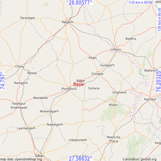
Bagar GPS coordinates[2]
28° 11' 16.224" North, 75° 30' 0.432" East
| Map corner | latitude | longitude |
|---|---|---|
| Upper-left | 28.80577°, | 74.797° |
| Center: | 28.18784°, | 75.50012° |
| Lower-right: | 27.56632°, | 76.20325° |
| Map W x H: | 137.8×137.8 km | = 85.6×85.6mi |
| max Lat: | 34.9274° ⇑14.8% North |
| Bagar: | 28.18784° |
| min Lat: | ⇓85.2% South 8.09008° |
| min Long | Bagar | max Long |
| 68.82655° | 75.50012° | 96.81° |
| W 21.5%⇐ | ⇒78.5% E |
Elevation
Elevation of Bagar is 328 m = 1076 ft, and this is 32.4 m = 106 ft above average elevation for this country.
| Max E: |
3681 m = 12077 ft | 29.9% |
| Bagar | 328 m 1076 ft | |
| Avg. | 295.6 m = 970 ft | |
Min E: |
1 m = 3 ft | 70.1% |
See also: India elevation on elevation.city.
Geographical zone
Bagar is located in North temperate zone (between Tropic of Cancer and the Arctic Circle). Distance of this Northern Tropic circle is 528.3 km =328.3 mi to South.| Distance of | km | miles | from Bagar |
|---|---|---|---|
| North Pole | 6872.9 | 4270.6 | to North |
| Arctic Circle | 4267 | 2651.4 | to North |
| Tropic Cancer | 528.3 | 328.3 | to South |
| Equator | 3134.2 | 1947.5 | to South |


Nearby cities:
15 places around Bagar: (largest is in red/bold)
• Bissāu
42 km =26.1 mi,  279°
279°
• Chidawa
14.9 km =9.3 mi,  67°
67°
• Chūru
53.8 km =33.4 mi, 283°
• Fatehpur
57.5 km =35.7 mi,  248°
248°
• Jhunjhunūn
12.2 km =7.6 mi,  235°
235°
• Khetri
35 km =21.7 mi,  126°
126°
• Lachhmangarh Sīkar
61.6 km =38.3 mi,  228°
228°
• Lohāru
40.4 km =25.1 mi,  48°
48°
• Mandholi Kalān
60.6 km =37.7 mi,  17°
17°
• Nawalgarh
43.5 km =27 mi,  210°
210°
• Neem ka Thana
57.2 km =35.5 mi,  150°
150°
• Pilāni
22.4 km =13.9 mi,  26°
26°
• Rājgarh
51.7 km =32.1 mi,  347°
347°
• Sūrajgarh
26.5 km =16.5 mi,  59°
59°
• Udaipur
51.8 km =32.2 mi,  183°
183°
Sources, notices
• [Note1] Compared only with cities in India existing in our database
• [Src1] Map data: © OpenStreetMap contributors (CC-BY-SA)
• [Src2] Other city data from geonames.org with taken over terms of usage.
• [Src3] Geographical zone / Annual Mean Temperature by Robert A. Rohde @ Wikipedia
