Rāmgarh geodata
Rāmgarh (Rajasthan) is a populated place; located in India in Asia/Kolkata (GMT+5.5) time zone. With population of 29,834 people, there are 1453 cities with bigger population in this country. Compared to other cities in India, 80.5% of cities are located further ↓South; 81.1% of cities are located further →East and 76.6% of cities have lower elevation than Rāmgarh. Note1


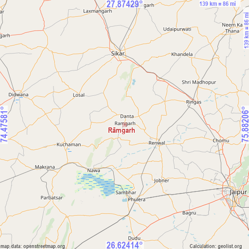
Rāmgarh GPS coordinates[2]
27° 15' 3.492" North, 75° 10' 44.148" East
| Map corner | latitude | longitude |
|---|---|---|
| Upper-left | 27.87429°, | 74.47581° |
| Center: | 27.25097°, | 75.17893° |
| Lower-right: | 26.62414°, | 75.88206° |
| Map W x H: | 139×139 km | = 86.4×86.4mi |
| max Lat: | 34.9274° ⇑19.5% North |
| Rāmgarh: | 27.25097° |
| min Lat: | ⇓80.5% South 8.09008° |
| min Long | Rāmgarh | max Long |
| 68.82655° | 75.17893° | 96.81° |
| W 18.9%⇐ | ⇒81.1% E |
Elevation
Elevation of Rāmgarh is 408 m = 1339 ft, and this is 112.4 m = 369 ft above average elevation for this country.
| Max E: |
3681 m = 12077 ft | 23.4% |
| Rāmgarh | 408 m 1339 ft | |
| Avg. | 295.6 m = 970 ft | |
Min E: |
1 m = 3 ft | 76.6% |
See also: India elevation on elevation.city.
Geographical zone
Rāmgarh is located in North temperate zone (between Tropic of Cancer and the Arctic Circle). Distance of this Northern Tropic circle is 424.1 km =263.5 mi to South.| Distance of | km | miles | from Rāmgarh |
|---|---|---|---|
| North Pole | 6977 | 4335.3 | to North |
| Arctic Circle | 4371.2 | 2716.1 | to North |
| Tropic Cancer | 424.1 | 263.5 | to South |
| Equator | 3030 | 1882.8 | to South |


Nearby cities:
15 places around Rāmgarh: (largest is in red/bold)
• Jobner
37.2 km =23.1 mi,  146°
146°
• Khandela
50.7 km =31.5 mi,  39°
39°
• Kuchāman
33.9 km =21.1 mi,  250°
250°
• Losal
30.8 km =19.1 mi,  302°
302°
• Makrāna
50.5 km =31.4 mi,  242°
242°
• Meethari Marwar
60.6 km =37.7 mi,  306°
306°
• Naraina
51.2 km =31.8 mi,  176°
176°
• Nāwa
31.1 km =19.3 mi,  214°
214°
• Parvatsar
57.6 km =35.8 mi,  225°
225°
• Phulera
42.4 km =26.3 mi,  171°
171°
• Rīngas
40.5 km =25.2 mi,  71°
71°
• Sri Mādhopur
47.7 km =29.6 mi,  59°
59°
• Sāmbhar
38.1 km =23.7 mi, 178°
• Sīkar
40.3 km =25 mi,  354°
354°
• Udaipur
59.9 km =37.2 mi,  28°
28°
Sources, notices
• [Note1] Compared only with cities in India existing in our database
• [Src1] Map data: © OpenStreetMap contributors (CC-BY-SA)
• [Src2] Other city data from geonames.org with taken over terms of usage.
• [Src3] Geographical zone / Annual Mean Temperature by Robert A. Rohde @ Wikipedia
