Kuchera geodata
Kuchera (Rajasthan) is a populated place; located in India in Asia/Kolkata (GMT+5.5) time zone. With population of 21,796 people, there are 1914 cities with bigger population in this country. Compared to other cities in India, 78.3% of cities are located further ↓South; 89.7% of cities are located further →East and 69% of cities have lower elevation than Kuchera. Note1


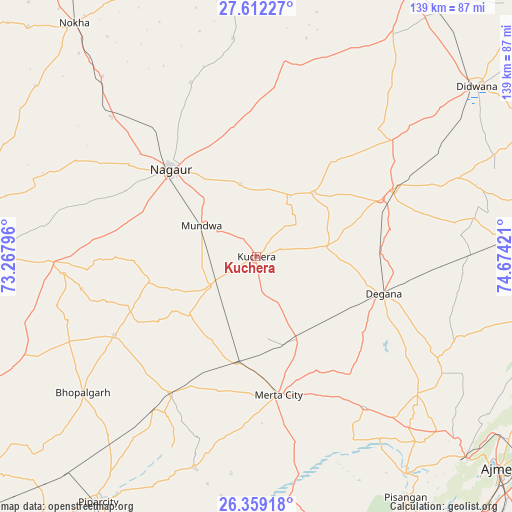
Kuchera GPS coordinates[2]
26° 59' 14.892" North, 73° 58' 15.888" East
| Map corner | latitude | longitude |
|---|---|---|
| Upper-left | 27.61227°, | 73.26796° |
| Center: | 26.98747°, | 73.97108° |
| Lower-right: | 26.35918°, | 74.67421° |
| Map W x H: | 139.3×139.3 km | = 86.6×86.6mi |
| max Lat: | 34.9274° ⇑21.7% North |
| Kuchera: | 26.98747° |
| min Lat: | ⇓78.3% South 8.09008° |
| min Long | Kuchera | max Long |
| 68.82655° | 73.97108° | 96.81° |
| W 10.3%⇐ | ⇒89.7% E |
Elevation
Elevation of Kuchera is 317 m = 1040 ft, and this is 21.4 m = 70 ft above average elevation for this country.
| Max E: |
3681 m = 12077 ft | 31% |
| Kuchera | 317 m 1040 ft | |
| Avg. | 295.6 m = 970 ft | |
Min E: |
1 m = 3 ft | 69% |
See also: India elevation on elevation.city.
Geographical zone
Kuchera is located in North temperate zone (between Tropic of Cancer and the Arctic Circle). Distance of this Northern Tropic circle is 394.8 km =245.3 mi to South.| Distance of | km | miles | from Kuchera |
|---|---|---|---|
| North Pole | 7006.3 | 4353.5 | to North |
| Arctic Circle | 4400.4 | 2734.3 | to North |
| Tropic Cancer | 394.8 | 245.3 | to South |
| Equator | 3000.7 | 1864.5 | to South |


Nearby cities:
15 places around Kuchera: (largest is in red/bold)
• Ajmer
89.1 km =55.4 mi,  131°
131°
• Basni
38.3 km =23.8 mi,  302°
302°
• Dīdwāna
75.4 km =46.9 mi,  52°
52°
• Jaitāran
87.1 km =54.1 mi,  182°
182°
• Kuchāman
89.5 km =55.6 mi,  78°
78°
• Lādnūn
85.3 km =53 mi,  29°
29°
• Makrāna
74.9 km =46.5 mi,  85°
85°
• Merta
38.2 km =23.7 mi,  170°
170°
• Mūndwa
16.9 km =10.5 mi, 299°
• Nokha
80.7 km =50.1 mi,  322°
322°
• Nāgaur
33.5 km =20.8 mi, 315°
• Parvatsar
79.6 km =49.5 mi,  98°
98°
• Pushkar
79.9 km =49.6 mi, 133°
• Pīpār
79.4 km =49.3 mi,  212°
212°
• Sūjāngarh
93.1 km =57.8 mi, 31°
Sources, notices
• [Note1] Compared only with cities in India existing in our database
• [Src1] Map data: © OpenStreetMap contributors (CC-BY-SA)
• [Src2] Other city data from geonames.org with taken over terms of usage.
• [Src3] Geographical zone / Annual Mean Temperature by Robert A. Rohde @ Wikipedia
