Parvatsar geodata
Parvatsar (Rajasthan) is a populated place; located in India in Asia/Kolkata (GMT+5.5) time zone. With population of 15,405 people, there are 2423 cities with bigger population in this country. Compared to other cities in India, 77.5% of cities are located further ↓South; 84.7% of cities are located further →East and 78.3% of cities have lower elevation than Parvatsar. Note1


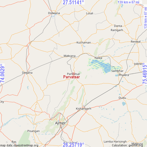
Parvatsar GPS coordinates[2]
26° 53' 9.744" North, 74° 45' 57.672" East
| Map corner | latitude | longitude |
|---|---|---|
| Upper-left | 27.51141°, | 74.0629° |
| Center: | 26.88604°, | 74.76602° |
| Lower-right: | 26.25719°, | 75.46915° |
| Map W x H: | 139.5×139.5 km | = 86.7×86.7mi |
| max Lat: | 34.9274° ⇑22.5% North |
| Parvatsar: | 26.88604° |
| min Lat: | ⇓77.5% South 8.09008° |
| min Long | Parvatsar | max Long |
| 68.82655° | 74.76602° | 96.81° |
| W 15.3%⇐ | ⇒84.7% E |
Elevation
Elevation of Parvatsar is 434 m = 1424 ft, and this is 138.4 m = 454 ft above average elevation for this country.
| Max E: |
3681 m = 12077 ft | 21.7% |
| Parvatsar | 434 m 1424 ft | |
| Avg. | 295.6 m = 970 ft | |
Min E: |
1 m = 3 ft | 78.3% |
See also: India elevation on elevation.city.
Geographical zone
Parvatsar is located in North temperate zone (between Tropic of Cancer and the Arctic Circle). Distance of this Northern Tropic circle is 383.5 km =238.3 mi to South.| Distance of | km | miles | from Parvatsar |
|---|---|---|---|
| North Pole | 7017.6 | 4360.5 | to North |
| Arctic Circle | 4411.7 | 2741.3 | to North |
| Tropic Cancer | 383.5 | 238.3 | to South |
| Equator | 2989.4 | 1857.5 | to South |


Nearby cities:
15 places around Parvatsar: (largest is in red/bold)
• Ajmer
49.9 km =31 mi,  194°
194°
• Dīdwāna
60.3 km =37.5 mi,  341°
341°
• Jobner
62.4 km =38.8 mi,  81°
81°
• Kishangarh
34 km =21.1 mi,  165°
165°
• Kuchāman
30.4 km =18.9 mi,  17°
17°
• Losal
59.1 km =36.7 mi,  14°
14°
• Makrāna
18 km =11.2 mi,  346°
346°
• Meethari Marwar
77.1 km =47.9 mi, 354°
• Naraina
44.9 km =27.9 mi,  103°
103°
• Nasīrābād
64.7 km =40.2 mi,  182°
182°
• Nāwa
27.7 km =17.2 mi,  57°
57°
• Phulera
47.2 km =29.3 mi,  91°
91°
• Pushkar
48.9 km =30.4 mi,  205°
205°
• Rāmgarh
57.6 km =35.8 mi,  45°
45°
• Sāmbhar
42.2 km =26.2 mi, 86°
Sources, notices
• [Note1] Compared only with cities in India existing in our database
• [Src1] Map data: © OpenStreetMap contributors (CC-BY-SA)
• [Src2] Other city data from geonames.org with taken over terms of usage.
• [Src3] Geographical zone / Annual Mean Temperature by Robert A. Rohde @ Wikipedia
