Manamadurai geodata
Manamadurai (Tamil Nadu) is a populated place; located in India in Asia/Kolkata (GMT+5.5) time zone. With population of 27,493 people, there are 1565 cities with bigger population in this country. Compared to other cities in India, 97.5% of cities are located further ↑North; 53.9% of cities are located further ←West and 74.2% of cities have higher elevation than Manamadurai. Note1


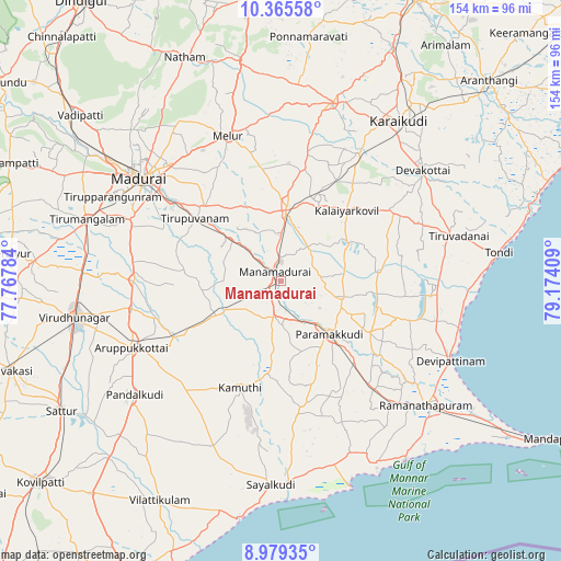
Manamadurai GPS coordinates[2]
9° 40' 23.448" North, 78° 28' 15.456" East
| Map corner | latitude | longitude |
|---|---|---|
| Upper-left | 10.36558°, | 77.76784° |
| Center: | 9.67318°, | 78.47096° |
| Lower-right: | 8.97935°, | 79.17409° |
| Map W x H: | 154.1×154.1 km | = 95.8×95.8mi |
| max Lat: | 34.9274° ⇑97.5% North |
| Manamadurai: | 9.67318° |
| min Lat: | ⇓2.5% South 8.09008° |
| min Long | Manamadurai | max Long |
| 68.82655° | 78.47096° | 96.81° |
| W 53.9%⇐ | ⇒46.1% E |
Elevation
Elevation of Manamadurai is 72 m = 236 ft, and this is 223.6 m = 734 ft below average elevation for this country.
| Max E: |
3681 m = 12077 ft | 74.2% |
| Avg. | 295.6 m = 970 ft | |
| Manamadurai | 72 m = 236 ft | |
Min E: |
1 m = 3 ft | 25.8% |
See also: India elevation on elevation.city.
Geographical zone
Manamadurai is located in North Torrid zone (between Equator and Tropic of Cancer). Distance of Equator is 1075.6 km =668.3 mi to South.| Distance of | km | miles | from Manamadurai |
|---|---|---|---|
| North Pole | 8931.5 | 5549.8 | to North |
| Arctic Circle | 6325.6 | 3930.5 | to North |
| Tropic Cancer | 1530.4 | 950.9 | to North |
| Equator | 1075.6 | 668.3 | to South |


Nearby cities:
15 places around Manamadurai: (largest is in red/bold)
• Abirāmam
25.9 km =16.1 mi,  187°
187°
• Aruppukkottai
45 km =28 mi,  246°
246°
• Devakottai
49.2 km =30.6 mi,  51°
51°
• Kamuthi
31.4 km =19.5 mi,  199°
199°
• Kariapatti
40.7 km =25.3 mi,  270°
270°
• Madurai
47.2 km =29.3 mi,  305°
305°
• Mangalam
21.2 km =13.2 mi,  61°
61°
• Melur
42.5 km =26.4 mi,  340°
340°
• Mudukulattūr
37.2 km =23.1 mi,  172°
172°
• Nāttarasankottai
23.6 km =14.7 mi,  22°
22°
• Paramagudi
19.3 km =12 mi,  137°
137°
• Sivaganga
19.4 km =12.1 mi,  4°
4°
• Tirupparangunram
49.4 km =30.7 mi,  297°
297°
• Tiruppuvanam
28.8 km =17.9 mi, 305°
• Tiruppālaikudi
50.9 km =31.6 mi,  106°
106°
Sources, notices
• [Note1] Compared only with cities in India existing in our database
• [Src1] Map data: © OpenStreetMap contributors (CC-BY-SA)
• [Src2] Other city data from geonames.org with taken over terms of usage.
• [Src3] Geographical zone / Annual Mean Temperature by Robert A. Rohde @ Wikipedia
