Sivaganga geodata
Sivaganga (Tamil Nadu) is a populated place; located in India in Asia/Kolkata (GMT+5.5) time zone. With population of 42,785 people, there are 1032 cities with bigger population in this country. Compared to other cities in India, 97% of cities are located further ↑North; 54% of cities are located further ←West and 67.9% of cities have higher elevation than Sivaganga. Note1


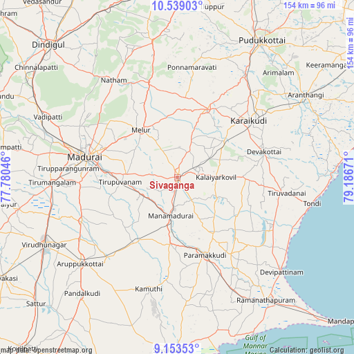
Sivaganga GPS coordinates[2]
9° 50' 49.236" North, 78° 29' 0.888" East
| Map corner | latitude | longitude |
|---|---|---|
| Upper-left | 10.53903°, | 77.78046° |
| Center: | 9.84701°, | 78.48358° |
| Lower-right: | 9.15353°, | 79.18671° |
| Map W x H: | 154.1×154.1 km | = 95.8×95.8mi |
| max Lat: | 34.9274° ⇑97% North |
| Sivaganga: | 9.84701° |
| min Lat: | ⇓3% South 8.09008° |
| min Long | Sivaganga | max Long |
| 68.82655° | 78.48358° | 96.81° |
| W 54%⇐ | ⇒46% E |
Elevation
Elevation of Sivaganga is 103 m = 338 ft, and this is 192.6 m = 632 ft below average elevation for this country.
| Max E: |
3681 m = 12077 ft | 67.9% |
| Avg. | 295.6 m = 970 ft | |
| Sivaganga | 103 m = 338 ft | |
Min E: |
1 m = 3 ft | 32.1% |
See also: Sivaganga elevation on elevation.city.
Geographical zone
Sivaganga is located in North Torrid zone (between Equator and Tropic of Cancer). Distance of Equator is 1094.9 km =680.3 mi to South.| Distance of | km | miles | from Sivaganga |
|---|---|---|---|
| North Pole | 8912.2 | 5537.8 | to North |
| Arctic Circle | 6306.3 | 3918.6 | to North |
| Tropic Cancer | 1511 | 938.9 | to North |
| Equator | 1094.9 | 680.3 | to South |


Nearby cities:
15 places around Sivaganga: (largest is in red/bold)
• Abirāmam
45.3 km =28.1 mi,  186°
186°
• Devakottai
38.8 km =24.1 mi,  73°
73°
• Kariapatti
46.2 km =28.7 mi,  245°
245°
• Kottaiyūr
44.9 km =27.9 mi,  49°
49°
• Kāraikkudi
39.5 km =24.5 mi, 51°
• Madurai
40.7 km =25.3 mi,  281°
281°
• Manamadurai
19.4 km =12.1 mi,  184°
184°
• Mangalam
19.5 km =12.1 mi,  118°
118°
• Melur
26 km =16.2 mi,  322°
322°
• Nāttarasankottai
8 km =5 mi, 72°
• Pallattūr
48.3 km =30 mi, 46°
• Paramagudi
35.4 km =22 mi,  160°
160°
• Ponnamarāvati
48.5 km =30.1 mi,  6°
6°
• Tirupparangunram
45.1 km =28 mi,  274°
274°
• Tiruppuvanam
24.8 km =15.4 mi,  264°
264°
Sources, notices
• [Note1] Compared only with cities in India existing in our database
• [Src1] Map data: © OpenStreetMap contributors (CC-BY-SA)
• [Src2] Other city data from geonames.org with taken over terms of usage.
• [Src3] Geographical zone / Annual Mean Temperature by Robert A. Rohde @ Wikipedia
