Tondi geodata
Tondi (Tamil Nadu) is a populated place; located in India in Asia/Kolkata (GMT+5.5) time zone. With population of 16,468 people, there are 2332 cities with bigger population in this country. Compared to other cities in India, 97.2% of cities are located further ↑North; 59.1% of cities are located further ←West and 97.4% of cities have higher elevation than Tondi. Note1


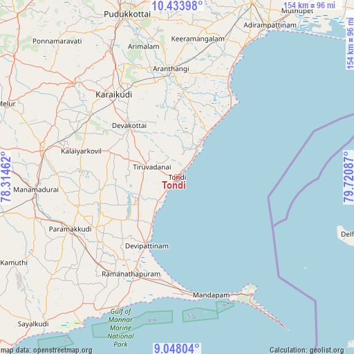
Tondi GPS coordinates[2]
9° 44' 30.228" North, 79° 1' 3.864" East
| Map corner | latitude | longitude |
|---|---|---|
| Upper-left | 10.43398°, | 78.31462° |
| Center: | 9.74173°, | 79.01774° |
| Lower-right: | 9.04804°, | 79.72087° |
| Map W x H: | 154.1×154.1 km | = 95.8×95.8mi |
| max Lat: | 34.9274° ⇑97.2% North |
| Tondi: | 9.74173° |
| min Lat: | ⇓2.8% South 8.09008° |
| min Long | Tondi | max Long |
| 68.82655° | 79.01774° | 96.81° |
| W 59.1%⇐ | ⇒40.9% E |
Elevation
Elevation of Tondi is 9 m = 30 ft, and this is 286.6 m = 940 ft below average elevation for this country.
| Max E: |
3681 m = 12077 ft | 97.4% |
| Avg. | 295.6 m = 970 ft | |
| Tondi | 9 m = 30 ft | |
Min E: |
1 m = 3 ft | 2.6% |
See also: India elevation on elevation.city.
Geographical zone
Tondi is located in North Torrid zone (between Equator and Tropic of Cancer). Distance of Equator is 1083.2 km =673.1 mi to South.| Distance of | km | miles | from Tondi |
|---|---|---|---|
| North Pole | 8923.9 | 5545.1 | to North |
| Arctic Circle | 6318 | 3925.8 | to North |
| Tropic Cancer | 1522.7 | 946.2 | to North |
| Equator | 1083.2 | 673.1 | to South |


Nearby cities:
15 places around Tondi: (largest is in red/bold)
• Arantāngi
48 km =29.8 mi,  356°
356°
• Arimalam
58.9 km =36.6 mi,  345°
345°
• Devakottai
31.2 km =19.4 mi,  316°
316°
• Kanadukattan
54.5 km =33.9 mi,  331°
331°
• Kottaiyūr
47.6 km =29.6 mi, 329°
• Kāraikkudi
45.3 km =28.1 mi, 322°
• Mandapam
53.1 km =33 mi,  167°
167°
• Mangalam
41.4 km =25.7 mi,  273°
273°
• Nambutalai
2 km =1.2 mi,  216°
216°
• Nāttarasankottai
52.8 km =32.8 mi,  285°
285°
• Pallattūr
50.7 km =31.5 mi, 332°
• Paramagudi
51.6 km =32.1 mi,  245°
245°
• Periyapattinam
53.7 km =33.4 mi,  193°
193°
• Ramanathapuram
46 km =28.6 mi,  206°
206°
• Tiruppālaikudi
24.4 km =15.2 mi, 206°
Sources, notices
• [Note1] Compared only with cities in India existing in our database
• [Src1] Map data: © OpenStreetMap contributors (CC-BY-SA)
• [Src2] Other city data from geonames.org with taken over terms of usage.
• [Src3] Geographical zone / Annual Mean Temperature by Robert A. Rohde @ Wikipedia
